Geolocalizza

Mappa topografica Laleham

Clicca sulla mappa per visualizzare l'altitudine.

A proposito di questa mappa

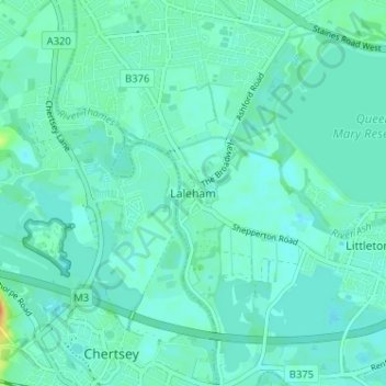
Nome: Mappa topografica Laleham, altitudine, rilievo.

Luogo: Laleham, Borough of Spelthorne, Surrey, England, TW18 1SD, United Kingdom (51.38890 -0.51027 51.42890 -0.47027)

Altitudine media: 14 m

Altitudine minima: 7 m

Altitudine massima: 44 m

Altre mappe topografiche

Clicca su una mappa per visualizzarne la topografia, l'altitudine e il rilievo.

Shepperton

United Kingdom > England > Surrey > Borough of Spelthorne

Shepperton has a long boundary with the River Thames in its southernmost salient, which almost surrounds Spelthorne. Old Shepperton is almost surrounded by the extreme southern meander within this. Prehistoric glacial retreat north of this has made the north bank almost flat for a considerable distance and as…

Altitudine media: 12 m

Equipaggiati per la tua prossima avventura:

🩺Kit Medico Avanzato - Kit per emergenze maggiori durante escursioni
🪶Fodera per Sacco a Pelo - Maggiore comfort e isolamento
🛌Sacco a Pelo - Sacco a pelo termico e compatto per outdoor
🌧️Coprizaino Antipioggia - Protezione universale per mantenere l'attrezzatura asciutta
🧴Protezione Solare Altitudine - Crema solare specifica per le forti radiazioni UV in montagna

In qualità di Affiliato Amazon, questo sito riceve una commissione sugli acquisti idonei, senza costi aggiuntivi per l’utente.