Geolocalizza

Mappa topografica White Coppice

Clicca sulla mappa per visualizzare l'altitudine.

A proposito di questa mappa

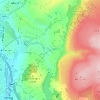
Nome: Mappa topografica White Coppice, altitudine, rilievo.

Luogo: White Coppice, Anglezarke, Chorley, Lancashire, England, PR6 9DB, United Kingdom (53.64667 -2.60436 53.68667 -2.56436)

Altitudine media: 184 m

Altitudine minima: 87 m

Altitudine massima: 324 m

Altre mappe topografiche

Clicca su una mappa per visualizzarne la topografia, l'altitudine e il rilievo.

Adlington

United Kingdom > England > Lancashire > Chorley > Adlington

Altitudine media: 95 m

River Darwen

United Kingdom > England > Lancashire > Chorley

Altitudine media: 123 m

Moss Wood

United Kingdom > England > Lancashire > Chorley

Altitudine media: 8 m

Withnell

United Kingdom > England > Lancashire > Chorley > Abbey Village

Altitudine media: 204 m

Bretherton

United Kingdom > England > Lancashire > Chorley > Bretherton

Altitudine media: 10 m

Coppull

United Kingdom > England > Lancashire > Chorley

The settlement has an Anglo Saxon name describing its topography derived from the Old English copp a hill top and hyll a hill. The township was variously recorded as Cophull and Cophulle in 1277, Copphull in 1351, Copthull in 1374 and Coppull from 1444.

Altitudine media: 80 m

Euxton

United Kingdom > England > Lancashire > Chorley > Euxton

Altitudine media: 50 m

Brindle

United Kingdom > England > Lancashire > Chorley > Brindle

Altitudine media: 114 m

Heskin

United Kingdom > England > Lancashire > Chorley

Altitudine media: 56 m

Rivington

United Kingdom > England > Lancashire > Chorley > Rivington

Altitudine media: 244 m

Heapey

United Kingdom > England > Lancashire > Chorley > Wheelton

Altitudine media: 127 m

Croston

United Kingdom > England > Lancashire > Chorley

Altitudine media: 8 m

Bretherton

United Kingdom > England > Lancashire > Chorley

Altitudine media: 10 m

Wheelton

United Kingdom > England > Lancashire > Chorley

Altitudine media: 183 m

Coppull

United Kingdom > England > Lancashire > Chorley

The settlement has an Anglo Saxon name describing its topography derived from the Old English copp a hill top and hyll a hill. The township was variously recorded as Cophull and Cophulle in 1277, Copphull in 1351, Copthull in 1374 and Coppull from 1444.

Altitudine media: 82 m

Equipaggiati per la tua prossima avventura:

🩺Kit Medico Avanzato - Kit per emergenze maggiori durante escursioni
🔋Batterie al Litio Ricaricabili - Batterie ad alta durata per dispositivi GPS e torce frontali
🪢Mezza Corda Alpinismo - Corda tecnica per sicurezza su ghiacciaio e creste
🪓Coltello Multiuso - Coltello multifunzione compatto per outdoor
🧲Supporto Smartphone Bici - Aggancio sicuro al manubrio per usare il telefono come GPS

In qualità di Affiliato Amazon, questo sito riceve una commissione sugli acquisti idonei, senza costi aggiuntivi per l’utente.