
Mappa topografica Welshpool
Mappa interattiva
Clicca sulla mappa per visualizzare l'altitudine.
A proposito di questa mappa
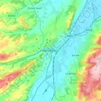
Nome: Mappa topografica Welshpool, altitudine, rilievo.
Luogo: Welshpool, Powys, Wales, SY21 7SD, United Kingdom (52.62007 -3.18742 52.70007 -3.10742)
Altitudine media: 156 m
Altitudine minima: 63 m
Altitudine massima: 412 m
The Mermaid Inn, 28 High Street, was very probably an early 16th-century merchant's house, placed on a burgage plot between the High Street and Alfred Jones Court. The timber-framed building has long storehouse or wing to the rear. The frontage was remodelled c. 1890, by Frank H. Shayler, architect, of Shrewsbury. Early illustrations of the building show that prior to this it had a thatched roof and that the timbering was not exposed. There is a passage to side with heavy box-framing in square panels, with brick infill exposed in side elevation and in rear wing. The frontage was exposed by Shayler to show decorative timber work on the upper storey. An Inn by the 19th century when it was owned by a family named Sparrow.
Altre mappe topografiche
Clicca su una mappa per visualizzarne la topografia, l'altitudine e il rilievo.
Cascob
United Kingdom > Wales > Powys
Cascob, Whitton, Powys, Wales, LD8 2NT, United Kingdom
Altitudine media: 293 m
Llangunllo
United Kingdom > Wales > Powys > Llangunllo
Llangunllo, Powys, Wales, United Kingdom
Altitudine media: 332 m
Black Mountains
United Kingdom > Wales > Powys > Craswall
Black Mountains, Craswall, Powys, Wales, NP7 7NP, United Kingdom
Altitudine media: 373 m
Heol-fanog
United Kingdom > Wales > Powys
Heol-fanog, Glyn Tarell, Powys, Wales, LD3 8LE, United Kingdom
Altitudine media: 296 m