
Mappa topografica Illingen
Clicca sulla mappa per visualizzare l'altitudine.
Illingen
The municipality (Gemeinde) of Illingen is located at the eastern edge of the Enzkreis district, within the state of Baden-Württemberg and Federal Republic of Germany. It covers an area of 29.36 square kilometers (11.34 sq mi) that lies within the metropolitan areas of Karlsruhe and Pforzheim. Illingen is physically located on the Keuper Uplands, just north of the Enz valley, between the Neckar basin [de] and the hilly Stromberg region. The largest watercourses within the municipality are the Schmiebach and Metter rivers. The lowest elevation in the municipality, 208 meters (682 ft) NN, lies along the Schmie while the highest, 395 meters (1,296 ft) NN, is the top of the Burgberg in the west.
A proposito di questa mappa
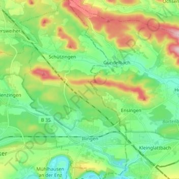
Nome: Mappa topografica Illingen, altitudine, rilievo.
Luogo: Illingen, Enzkreis, Baden-Württemberg, 75428, Germany (48.93638 8.86926 49.02132 8.94922)
Altitudine media: 279 m
Altitudine minima: 202 m
Altitudine massima: 437 m
Altre mappe topografiche
Clicca su una mappa per visualizzarne la topografia, l'altitudine e il rilievo.
Holzbachtal
Germany > Baden-Württemberg > Enzkreis > Straubenhardt > Langenalb
Altitudine media: 449 m