
Fai una donazione
Equipaggiati per la tua prossima avventura:
In qualità di Affiliato Amazon, questo sito riceve una commissione sugli acquisti idonei, senza costi aggiuntivi per l’utente.
Mappa topografica High Bluff
Clicca sulla mappa per visualizzare l'altitudine.
Fai una donazione
Equipaggiati per la tua prossima avventura:
In qualità di Affiliato Amazon, questo sito riceve una commissione sugli acquisti idonei, senza costi aggiuntivi per l’utente.
A proposito di questa mappa
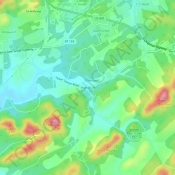
Nome: Mappa topografica High Bluff, altitudine, rilievo.
Luogo: High Bluff, Knox County, Tennessee, United States (35.87175 -83.86323 35.91175 -83.82323)
Altitudine media: 298 m
Altitudine minima: 255 m
Altitudine massima: 388 m
Fai una donazione
Equipaggiati per la tua prossima avventura:
In qualità di Affiliato Amazon, questo sito riceve una commissione sugli acquisti idonei, senza costi aggiuntivi per l’utente.
Altre mappe topografiche
Clicca su una mappa per visualizzarne la topografia, l'altitudine e il rilievo.
Knoxville
United States > Tennessee > Knox County
According to the United States Census Bureau, the city has a total area of 104.2 square miles (269.8 km2), of which 98.5 square miles (255.2 km2) is land and 5.6 square miles (14.6 km2), or 5.42%, is water. Elevations range from just over 800 feet (240 m) along the riverfront to just over 1,000 feet (300 m) on…
Altitudine media: 307 m
Knoxville
United States > Tennessee > Knox County
Knoxville features a diverse topography characterized by its position in the Great Appalachian Valley. The city sits at an elevation of approximately 886 feet above sea level, nestled between the Great Smoky Mountains to the east and the Cumberland Plateau to the west. This geographical setup results in a…
Altitudine media: 307 m
Fai una donazione
Equipaggiati per la tua prossima avventura:
In qualità di Affiliato Amazon, questo sito riceve una commissione sugli acquisti idonei, senza costi aggiuntivi per l’utente.
Halls Crossroads
United States > Tennessee > Knox County
It is located at 36°04′49″N 83°56′33″W / 36.08028°N 83.94250°W / 36.08028; -83.94250. It has an elevation of 1,040 feet.
Altitudine media: 346 m
Fai una donazione
Equipaggiati per la tua prossima avventura:
In qualità di Affiliato Amazon, questo sito riceve una commissione sugli acquisti idonei, senza costi aggiuntivi per l’utente.
Victor Ashe Park
United States > Tennessee > Knox County > Knoxville > Windsor Park
Altitudine media: 314 m
Knoxville
United States > Tennessee > Knox County
According to the United States Census Bureau, the city has a total area of 104.2 square miles (269.8 km2), of which 98.5 square miles (255.2 km2) is land and 5.6 square miles (14.6 km2), or 5.42%, is water. Elevations range from just over 800 feet (240 m) along the riverfront to just over 1,000 feet (300 m) on…
Altitudine media: 307 m
House Mountain
United States > Tennessee > Knox County
House Mountain is a mountain located in Corryton, Tennessee, United States, about 8 miles (13 km) northeast of Knoxville. Rising to an elevation of 2,064 feet (629 m) above sea level, House Mountain is the highest point in Knox County.
Altitudine media: 394 m
Fai una donazione
Equipaggiati per la tua prossima avventura:
In qualità di Affiliato Amazon, questo sito riceve una commissione sugli acquisti idonei, senza costi aggiuntivi per l’utente.
Knoxville
United States > Tennessee > Knox County
According to the United States Census Bureau, the city has a total area of 104.2 square miles (269.8 km2), of which 98.5 square miles (255.2 km2) is land and 5.6 square miles (14.6 km2), or 5.42%, is water. Elevations range from just over 800 feet (240 m) along the riverfront to just over 1,000 feet (300 m) on…
Altitudine media: 307 m
Halls Crossroads
United States > Tennessee > Knox County
It is located at 36°04′49″N 83°56′33″W / 36.08028°N 83.94250°W / 36.08028; -83.94250. It has an elevation of 1,040 feet.
Altitudine media: 346 m
Fai una donazione
Equipaggiati per la tua prossima avventura:
In qualità di Affiliato Amazon, questo sito riceve una commissione sugli acquisti idonei, senza costi aggiuntivi per l’utente.