
Fai una donazione
Equipaggiati per la tua prossima avventura:
In qualità di Affiliato Amazon, questo sito riceve una commissione sugli acquisti idonei, senza costi aggiuntivi per l’utente.
Mappa topografica Belvidere
Clicca sulla mappa per visualizzare l'altitudine.
Fai una donazione
Equipaggiati per la tua prossima avventura:
In qualità di Affiliato Amazon, questo sito riceve una commissione sugli acquisti idonei, senza costi aggiuntivi per l’utente.
Belvidere
Belvidere developed on both sides of the Kishwaukee River in north central Illinois. It is 76 miles from downtown Chicago on Routes 20, 76 and the Northern Illinois Toll road. Belvidere is an industrial community surrounded by prosperous farms. It is the County Seat with an estimated 2006 county population of over 52,000. The altitude is 800 feet above sea level, average temperatures are: 73 degrees F in the summer; 24 degrees F in the winter, and the average rainfall is 33.3 inches, and the average annual snowfall is 35.3 inches.
Fai una donazione
Equipaggiati per la tua prossima avventura:
In qualità di Affiliato Amazon, questo sito riceve una commissione sugli acquisti idonei, senza costi aggiuntivi per l’utente.
A proposito di questa mappa
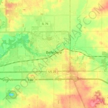
Nome: Mappa topografica Belvidere, altitudine, rilievo.
Altitudine media: 244 m
Altitudine minima: 208 m
Altitudine massima: 282 m
Fai una donazione
Equipaggiati per la tua prossima avventura:
In qualità di Affiliato Amazon, questo sito riceve una commissione sugli acquisti idonei, senza costi aggiuntivi per l’utente.
Altre mappe topografiche
Clicca su una mappa per visualizzarne la topografia, l'altitudine e il rilievo.