
Fai una donazione
Equipaggiati per la tua prossima avventura:
In qualità di Affiliato Amazon, questo sito riceve una commissione sugli acquisti idonei, senza costi aggiuntivi per l’utente.
Mappa topografica Darien
Clicca sulla mappa per visualizzare l'altitudine.
Fai una donazione
Equipaggiati per la tua prossima avventura:
In qualità di Affiliato Amazon, questo sito riceve una commissione sugli acquisti idonei, senza costi aggiuntivi per l’utente.
Darien
On its east side, Long Neck Point Road stretches south beginning near the Ring's End Landing bridge and terminating at the southerly most tip of land. This area is somewhat inland and away from the eastern shoreline and at a relatively high elevation above the water. The west coast of Long Neck runs along Goodwives River and includes Pear Tree Point. Situated on Noroton Harbor, Pear Tree Point includes a public beach (Pear Tree Point Beach Park) and a private club (Darien Boat Club). Pear Tree Point Road, begins at the Ring's End Landing bridge, runs south along the western side of Long Neck adjacent to "The Gut" and to outer Noroton Harbor. This charming route hugs the shoreline at an elevation close enough to the tides such that storm conditions can bring the water level over the road. Approximately half-way south along the peninsula, Pear Tree Point Road turns abruptly to the east, ninety degrees, heading uphill and connecting to Long Neck Point Road, distinguishing Long Neck from Long Neck Point.
Fai una donazione
Equipaggiati per la tua prossima avventura:
In qualità di Affiliato Amazon, questo sito riceve una commissione sugli acquisti idonei, senza costi aggiuntivi per l’utente.
A proposito di questa mappa
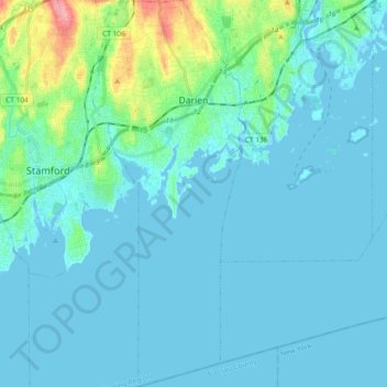
Nome: Mappa topografica Darien, altitudine, rilievo.
Altitudine media: 12 m
Altitudine minima: -2 m
Altitudine massima: 98 m
Fai una donazione
Equipaggiati per la tua prossima avventura:
In qualità di Affiliato Amazon, questo sito riceve una commissione sugli acquisti idonei, senza costi aggiuntivi per l’utente.
Altre mappe topografiche
Clicca su una mappa per visualizzarne la topografia, l'altitudine e il rilievo.
Old Greenwich
United States > Connecticut > Western Connecticut Planning Region > Greenwich
Altitudine media: 12 m
Sandy Hook
United States > Connecticut > Western Connecticut Planning Region > Newtown
Altitudine media: 113 m
Candlewood Lake Club
United States > Connecticut > Western Connecticut Planning Region > New Milford
Altitudine media: 143 m
Cannondale
United States > Connecticut > Western Connecticut Planning Region > Wilton
Altitudine media: 110 m
Fai una donazione
Equipaggiati per la tua prossima avventura:
In qualità di Affiliato Amazon, questo sito riceve una commissione sugli acquisti idonei, senza costi aggiuntivi per l’utente.
Taylor Corners
United States > Connecticut > Western Connecticut Planning Region > New Fairfield
Altitudine media: 226 m
Mianus
United States > Connecticut > Western Connecticut Planning Region > Greenwich
Altitudine media: 23 m
Winnipauk
United States > Connecticut > Western Connecticut Planning Region > Norwalk
Altitudine media: 51 m
West Norwalk
United States > Connecticut > Western Connecticut Planning Region > Norwalk
Altitudine media: 50 m
Fai una donazione
Equipaggiati per la tua prossima avventura:
In qualità di Affiliato Amazon, questo sito riceve una commissione sugli acquisti idonei, senza costi aggiuntivi per l’utente.
Godfrey Corner
United States > Connecticut > Western Connecticut Planning Region > Weston
Altitudine media: 110 m
North Mianus
United States > Connecticut > Western Connecticut Planning Region > Greenwich
Altitudine media: 32 m
Saugatuck
United States > Connecticut > Western Connecticut Planning Region > Westport
Altitudine media: 15 m
Five Points
United States > Connecticut > Western Connecticut Planning Region > Redding Ridge
Altitudine media: 185 m
Fai una donazione
Equipaggiati per la tua prossima avventura:
In qualità di Affiliato Amazon, questo sito riceve una commissione sugli acquisti idonei, senza costi aggiuntivi per l’utente.
Daniels Mill
United States > Connecticut > Western Connecticut Planning Region > New Canaan
Altitudine media: 100 m
Thomas Mountain
United States > Connecticut > Western Connecticut Planning Region > Danbury
Altitudine media: 197 m
Germantown
United States > Connecticut > Western Connecticut Planning Region > Danbury
Altitudine media: 121 m
King Street
United States > Connecticut > Western Connecticut Planning Region > Danbury
Altitudine media: 237 m
Fai una donazione
Equipaggiati per la tua prossima avventura:
In qualità di Affiliato Amazon, questo sito riceve una commissione sugli acquisti idonei, senza costi aggiuntivi per l’utente.
Pinneys Corners
United States > Connecticut > Western Connecticut Planning Region > New Canaan
Altitudine media: 143 m
Riverside
United States > Connecticut > Western Connecticut Planning Region > Greenwich > Old Greenwich
Altitudine media: 13 m
Beaver Brook
United States > Connecticut > Western Connecticut Planning Region > Danbury
Altitudine media: 119 m
North Stamford
United States > Connecticut > Western Connecticut Planning Region > Stamford
Altitudine media: 89 m
Fai una donazione
Equipaggiati per la tua prossima avventura:
In qualità di Affiliato Amazon, questo sito riceve una commissione sugli acquisti idonei, senza costi aggiuntivi per l’utente.
Mianus
United States > Connecticut > Western Connecticut Planning Region > Greenwich
Altitudine media: 23 m
Great Plain
United States > Connecticut > Western Connecticut Planning Region > Danbury
Altitudine media: 132 m
Byram
United States > Connecticut > Western Connecticut Planning Region > Greenwich
Altitudine media: 19 m
Wataba Lake
United States > Connecticut > Western Connecticut Planning Region > Ridgefield
Altitudine media: 205 m
Fai una donazione
Equipaggiati per la tua prossima avventura:
In qualità di Affiliato Amazon, questo sito riceve una commissione sugli acquisti idonei, senza costi aggiuntivi per l’utente.
Ponus
United States > Connecticut > Western Connecticut Planning Region > New Canaan
Altitudine media: 77 m
Tokeneke
United States > Connecticut > Western Connecticut Planning Region > Darien
Altitudine media: 14 m
Roxbury
United States > Connecticut > Western Connecticut Planning Region > Stamford
Altitudine media: 48 m
Deer Hill
United States > Connecticut > Western Connecticut Planning Region > Danbury
Altitudine media: 135 m
Fai una donazione
Equipaggiati per la tua prossima avventura:
In qualità di Affiliato Amazon, questo sito riceve una commissione sugli acquisti idonei, senza costi aggiuntivi per l’utente.
Long Ridge
United States > Connecticut > Western Connecticut Planning Region > Stamford
Altitudine media: 126 m
King Street
United States > Connecticut > Western Connecticut Planning Region > Danbury
Altitudine media: 237 m
Northfield
United States > Connecticut > Western Connecticut Planning Region > Stamford
Altitudine media: 25 m
Town Open Space (Ashford Lane)
United States > Connecticut > Western Connecticut Planning Region > Newtown
Altitudine media: 200 m
Fai una donazione
Equipaggiati per la tua prossima avventura:
In qualità di Affiliato Amazon, questo sito riceve una commissione sugli acquisti idonei, senza costi aggiuntivi per l’utente.
South End
United States > Connecticut > Western Connecticut Planning Region > Stamford
Altitudine media: 11 m
Godfrey Corner
United States > Connecticut > Western Connecticut Planning Region > Weston
Altitudine media: 110 m
Bold Rock
United States > Connecticut > Western Connecticut Planning Region > Darien
Altitudine media: 58 m
Mill River Park
United States > Connecticut > Western Connecticut Planning Region > Stamford
Altitudine media: 18 m
Fai una donazione
Equipaggiati per la tua prossima avventura:
In qualità di Affiliato Amazon, questo sito riceve una commissione sugli acquisti idonei, senza costi aggiuntivi per l’utente.
Wildmans Landing
United States > Connecticut > Western Connecticut Planning Region > Danbury
Altitudine media: 156 m
Chimney Point
United States > Connecticut > Western Connecticut Planning Region > New Milford
Altitudine media: 142 m
Five Points
United States > Connecticut > Western Connecticut Planning Region > Redding Ridge
Altitudine media: 185 m
Palestine
United States > Connecticut > Western Connecticut Planning Region > Newtown
Altitudine media: 184 m
Fai una donazione
Equipaggiati per la tua prossima avventura:
In qualità di Affiliato Amazon, questo sito riceve una commissione sugli acquisti idonei, senza costi aggiuntivi per l’utente.
Beckettville
United States > Connecticut > Western Connecticut Planning Region > Danbury
Altitudine media: 155 m
Taylor Corners
United States > Connecticut > Western Connecticut Planning Region > New Fairfield
Altitudine media: 226 m
Contentment Island
United States > Connecticut > Western Connecticut Planning Region > Darien
Altitudine media: 63 m
Belltown
United States > Connecticut > Western Connecticut Planning Region > Stamford
Altitudine media: 32 m
Fai una donazione
Equipaggiati per la tua prossima avventura:
In qualità di Affiliato Amazon, questo sito riceve una commissione sugli acquisti idonei, senza costi aggiuntivi per l’utente.
Palmers Hill
United States > Connecticut > Western Connecticut Planning Region > Stamford
Altitudine media: 31 m
Glenville
United States > Connecticut > Western Connecticut Planning Region > Greenwich
Altitudine media: 54 m
Turn of River
United States > Connecticut > Western Connecticut Planning Region > Stamford
Altitudine media: 58 m
Riverbank
United States > Connecticut > Western Connecticut Planning Region > Stamford
Altitudine media: 72 m
Fai una donazione
Equipaggiati per la tua prossima avventura:
In qualità di Affiliato Amazon, questo sito riceve una commissione sugli acquisti idonei, senza costi aggiuntivi per l’utente.
Honey Hill
United States > Connecticut > Western Connecticut Planning Region > Wilton
Altitudine media: 126 m
Riverside
United States > Connecticut > Western Connecticut Planning Region > Greenwich > Old Greenwich
Altitudine media: 13 m
Candlewood Springs
United States > Connecticut > Western Connecticut Planning Region > New Milford
Altitudine media: 146 m
Candlewood Orchards
United States > Connecticut > Western Connecticut Planning Region > Brookfield
Altitudine media: 141 m
Fai una donazione
Equipaggiati per la tua prossima avventura:
In qualità di Affiliato Amazon, questo sito riceve una commissione sugli acquisti idonei, senza costi aggiuntivi per l’utente.