
Mappa topografica Amarillo
Clicca sulla mappa per visualizzare l'altitudine.
Amarillo
Extreme temperatures range from −16 °F (−26.7 °C) on February 12, 1899 to 111 °F (43.9 °C) on June 26, 2011, but lows do not typically dip to 0 °F or −17.8 °C in most years, while highs above 100 °F or 37.8 °C are seen on 4.7 days on average. On average, there are 5.9 days of lows at or below 10 °F or −12.2 °C, 8.8 days where the temperature fails to rise above freezing, and 61 days of 90 °F (32.2 °C)+ highs. Unlike in the Rio Grande Valley or eastern portions of Texas, days where the low does not fall below 70 °F or 21.1 °C are relatively rare, due to the aridity and elevation. Blizzards occur occasionally, but snowfall is typically light, averaging nearly 18 inches or 46 centimeters seasonally and the median figure is near 10 inches or 25 centimeters. Amarillo is also recorded as the windiest city in the U.S. by the Weather Channel.
A proposito di questa mappa
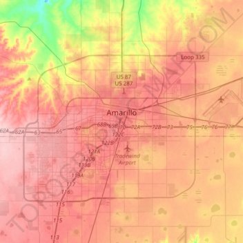
Nome: Mappa topografica Amarillo, altitudine, rilievo.
Luogo: Amarillo, Potter County, Texas, United States (35.09449 -101.96357 35.29448 -101.65368)
Altitudine media: 1’098 m
Altitudine minima: 1’001 m
Altitudine massima: 1’158 m
Altre mappe topografiche
Clicca su una mappa per visualizzarne la topografia, l'altitudine e il rilievo.
Bushland
United States > Texas > Potter County
Bushland is located at 35°11′31″N 102°03′53″W / 35.19194°N 102.06472°W / 35.19194; -102.06472 (35.1919978, -102.0646392), at an elevation of 3,825 feet. The community is situated along Interstate 40, approximately 14 miles west of Amarillo in southwestern Potter County.
Altitudine media: 1’167 m
Amarillo
United States > Texas > Potter County
Extreme temperatures range from −16 °F (−26.7 °C) on February 12, 1899 to 111 °F (43.9 °C) on June 26, 2011, but lows do not typically dip to 0 °F or −17.8 °C in most years, while highs above 100 °F or 37.8 °C are seen on 4.7 days on average. On average, there are 5.9 days of lows at or below 10…
Altitudine media: 1’097 m