
Mappa topografica Moab
Mappa interattiva
Clicca sulla mappa per visualizzare l'altitudine.
Moab
Moab is just south of the Colorado River, at an elevation of 4,025 feet (1,227 m) on the Colorado Plateau. It is 18 miles (29 km) west of the Utah/Colorado state line. Via U.S. Route 191, it is 31 miles (50 km) south of Interstate 70 at Crescent Junction, and it is 54 miles (87 km) north of Monticello. Via Utah State Route 128 it is 46 miles (74 km) southwest of Cisco. The entrance to Arches National Park is 4 miles (6 km) north of Moab on US 191. Hurrah Pass is located on the trail between Moab and Chicken Corners.
A proposito di questa mappa
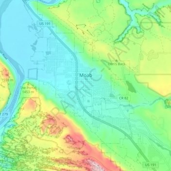
Nome: Mappa topografica Moab, altitudine, rilievo.
Luogo: Moab, Grand County, Utah, 84532, United States (38.53621 -109.57965 38.60318 -109.51532)
Altitudine media: 1’357 m
Altitudine minima: 1’200 m
Altitudine massima: 1’746 m