
Mappa topografica Bella Vista
Mappa interattiva
Clicca sulla mappa per visualizzare l'altitudine.
A proposito di questa mappa
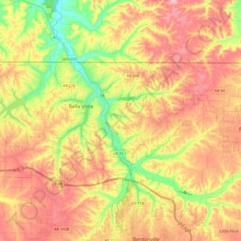
Nome: Mappa topografica Bella Vista, altitudine, rilievo.
Altitudine media: 371 m
Altitudine minima: 284 m
Altitudine massima: 448 m
The city of Bella Vista is located on the Springfield Plateau of the Ozark Mountains. Oak/hickory forests, along with valleys, creeks, and steep rises, characterize the city's topography. Bella Vista is located north of Bentonville and Rogers and is the northernmost Arkansas city in the Standard Metropolitan Statistical Area (which includes McDonald County, Missouri). The city has been experiencing a population and building boom in recent years, as indicated by a 60% growth in population between the 2000 and 2010 censuses.