
Mappa topografica Cornish
Mappa interattiva
Clicca sulla mappa per visualizzare l'altitudine.
A proposito di questa mappa
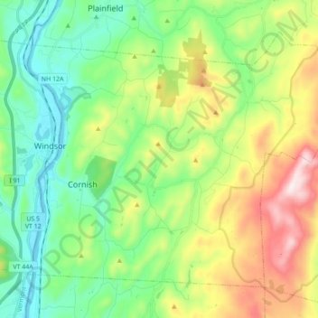
Nome: Mappa topografica Cornish, altitudine, rilievo.
Luogo: Cornish, Sullivan County, New Hampshire, United States (43.42379 -72.39912 43.52518 -72.22558)
Altitudine media: 272 m
Altitudine minima: 83 m
Altitudine massima: 945 m
According to the United States Census Bureau, the town has a total area of 42.6 square miles (110.4 km2), of which 42.0 square miles (108.7 km2) are land and 0.66 square miles (1.7 km2) are water, comprising 1.54% of the town.[1] The Connecticut River forms the western boundary of the town, which is also the New Hampshire–Vermont border. The town is drained by direct tributaries of the Connecticut: Blow-me-down Brook, Mill Brook, and Walker Brook; and by Redwater Brook, which flows south to the Sugar River in Claremont before that river joins the Connecticut.[5] The long ridge of Croydon Mountain follows the eastern boundary of town; the highest point in town is a knob on Croydon Mountain which reaches an elevation of 2,323 ft (708 m) above sea level.[6] The eastern part of the town is a portion of the approximately 25,000-acre (100 km2) Blue Mountain Forest Association private game preserve, also known locally as Corbin Park, named after its founder, Austin Corbin.
Altre mappe topografiche
Clicca su una mappa per visualizzarne la topografia, l'altitudine e il rilievo.
Charlestown
United States > New Hampshire > Sullivan County
Charlestown, Sullivan County, New Hampshire, 03603, United States
Altitudine media: 256 m