
Mappa topografica Esher
Mappa interattiva
Clicca sulla mappa per visualizzare l'altitudine.
Esher
Esher is an outlying suburb of London near the London-Surrey Border, and with Esher Commons at its southern end, the town marks one limit of the Greater London Built-Up Area. Esher has a linear commercial high street and is otherwise suburban in density, with varying elevations, few high rise buildings and very short sections of dual carriageway within the ward itself. Esher covers a large area, between 13 and 15.4 miles southwest of Charing Cross.[n 1] In the south it is bounded by the A3 Portsmouth Road which is of urban motorway standard and buffered by the Esher Commons.
A proposito di questa mappa
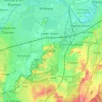
Nome: Mappa topografica Esher, altitudine, rilievo.
Luogo: Esher, Elmbridge, Surrey, England, KT10 9QU, United Kingdom (51.32939 -0.40542 51.40939 -0.32542)
Altitudine media: 27 m
Altitudine minima: -2 m
Altitudine massima: 88 m
Altre mappe topografiche
Clicca su una mappa per visualizzarne la topografia, l'altitudine e il rilievo.