
Mappa topografica Wildeck
Clicca sulla mappa per visualizzare l'altitudine.
A proposito di questa mappa
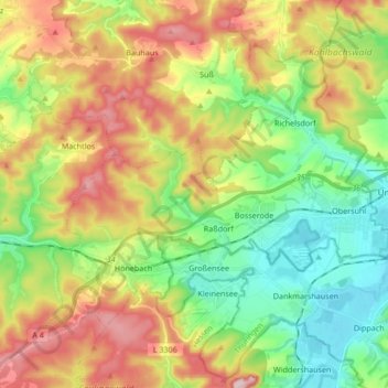
Nome: Mappa topografica Wildeck, altitudine, rilievo.
Luogo: Wildeck, Landkreis Hersfeld-Rotenburg, Hesse, 36208, Germany (50.91509 9.89623 50.99653 10.06485)
Altitudine media: 330 m
Altitudine minima: 208 m
Altitudine massima: 508 m
Altre mappe topografiche
Clicca su una mappa per visualizzarne la topografia, l'altitudine e il rilievo.
Bad Hersfeld
Germany > Hesse > Landkreis Hersfeld-Rotenburg
The Flugplatz Johannesberg has the status of Special Airfield. The runway, some 671 m long and 18 m wide, is paved with asphalt and oriented in a north–south direction. The airfield lies on the Johannesberg in the like-named outlying centre at an elevation of 284 m above sea level.
Altitudine media: 281 m