
Fai una donazione
Equipaggiati per la tua prossima avventura:
In qualità di Affiliato Amazon, questo sito riceve una commissione sugli acquisti idonei, senza costi aggiuntivi per l’utente.
Mappa topografica Zona Sur
Clicca sulla mappa per visualizzare l'altitudine.
Fai una donazione
Equipaggiati per la tua prossima avventura:
In qualità di Affiliato Amazon, questo sito riceve una commissione sugli acquisti idonei, senza costi aggiuntivi per l’utente.
Zona Sur
Although many lakes can be found in the Andean and coastal regions of central Chile, the south (Sur de Chile) has the country's most lakes. Southern Chile stretches from below the Río Bío-Bío at about 37° south latitude to below Isla de Chiloé at about 43.4° south latitude. In this lake district of Chile, the valley between the Andes and the coastal range is closer to sea level, and the hundreds of rivers that descend from the Andes form lakes, some quite large, as they reach the lower elevations. They drain into the ocean through other rivers, some of which (principally the Calle-Calle River, which flows by the city of Valdivia) are the only ones in the whole country that are navigable for any stretch. The Central Valley's southernmost portion is submerged in the ocean and forms the Golfo de Ancud. Isla de Chiloé, with its rolling hills, is the last important elevation of the coastal range of mountains.
Fai una donazione
Equipaggiati per la tua prossima avventura:
In qualità di Affiliato Amazon, questo sito riceve una commissione sugli acquisti idonei, senza costi aggiuntivi per l’utente.
A proposito di questa mappa
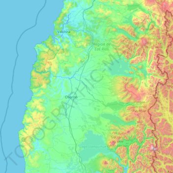
Nome: Mappa topografica Zona Sur, altitudine, rilievo.
Altitudine media: 399 m
Altitudine minima: -2 m
Altitudine massima: 3’145 m
Fai una donazione
Equipaggiati per la tua prossima avventura:
In qualità di Affiliato Amazon, questo sito riceve una commissione sugli acquisti idonei, senza costi aggiuntivi per l’utente.