
Fai una donazione
Equipaggiati per la tua prossima avventura:
In qualità di Affiliato Amazon, questo sito riceve una commissione sugli acquisti idonei, senza costi aggiuntivi per l’utente.
Mappa topografica Dehrn
Clicca sulla mappa per visualizzare l'altitudine.
Fai una donazione
Equipaggiati per la tua prossima avventura:
In qualità di Affiliato Amazon, questo sito riceve una commissione sugli acquisti idonei, senza costi aggiuntivi per l’utente.
A proposito di questa mappa
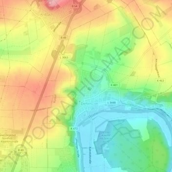
Nome: Mappa topografica Dehrn, altitudine, rilievo.
Luogo: Dehrn, Runkel, Landkreis Limburg-Weilburg, Hessen, Deutschland (50.40497 8.08354 50.44021 8.12188)
Altitudine media: 172 m
Altitudine minima: 110 m
Altitudine massima: 242 m
Fai una donazione
Equipaggiati per la tua prossima avventura:
In qualità di Affiliato Amazon, questo sito riceve una commissione sugli acquisti idonei, senza costi aggiuntivi per l’utente.
Altre mappe topografiche
Clicca su una mappa per visualizzarne la topografia, l'altitudine e il rilievo.
Steeden
Deutschland > Hessen > Landkreis Limburg-Weilburg > Runkel > Steeden
Die in Nord-Süd-Richtung länglich verlaufende, rund 400 Hektar große Gemarkung mit einem Ausläufer nach Osten grenzt im Norden an den Beselicher Ortsteil Niedertiefenbach, im Nordosten an Hofen, im Osten an Schadeck, im Südosten und Süden an die Kernstadt Runkel, im Südwesten an Ennerich und im Westen…
Altitudine media: 158 m