
Mappa topografica Town of Nanticoke
Mappa interattiva
Clicca sulla mappa per visualizzare l'altitudine.
A proposito di questa mappa
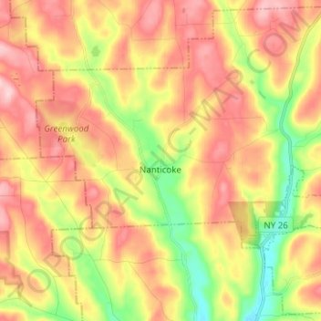
Nome: Mappa topografica Town of Nanticoke, altitudine, rilievo.
Altitudine media: 396 m
Altitudine minima: 288 m
Altitudine massima: 489 m
Altre mappe topografiche
Clicca su una mappa per visualizzarne la topografia, l'altitudine e il rilievo.
Town of Binghamton
United States > New York > Broome County
Town of Binghamton, Broome County, New York, 13903, United States
Altitudine media: 417 m
Crocker Island
United States > New York > Broome County > Village of Johnson City
Crocker Island, Village of Johnson City, Town of Union, Broome County, New York, 13902, United States
Altitudine media: 411 m
Nineveh
United States > New York > Broome County
Nineveh, Town of Colesville, Broome County, New York, United States
Altitudine media: 338 m
City of Binghamton
United States > New York > Broome County
City of Binghamton, Broome County, New York, 13905, United States
Altitudine media: 321 m
Oquaga Lake
United States > New York > Broome County > Town of Sanford
Oquaga Lake, Town of Sanford, Broome County, New York, United States
Altitudine media: 515 m
Binghamton
United States > New York > Broome County > Binghamton
Binghamton, Broome County, New York, 13903, United States
Altitudine media: 397 m
Town of Vestal
United States > New York > Broome County
Town of Vestal, Union, Broome County, New York, United States
Altitudine media: 372 m
Village of Johnson City
United States > New York > Broome County
Village of Johnson City, Town of Union, Broome County, New York, 13790, United States
Altitudine media: 309 m
Flowers
United States > New York > Broome County > Flowers
Flowers, Windsor Town, Broome County, New York, 13865, United States
Altitudine media: 484 m
Village of Deposit
United States > New York > Broome County
Village of Deposit, Town of Sanford, Broome County, New York, United States
Altitudine media: 356 m