Geolocalizza
👉 Easily get elevation data in JSON, GeoTIFF and KML formats using Elevation API
Grazie per il supporto a questo sito ❤️
Fai una donazione

Mappa topografica Gateshead

Clicca sulla mappa per visualizzare l'altitudine.

👉 Easily get elevation data in JSON, GeoTIFF and KML formats using Elevation API
Grazie per il supporto a questo sito ❤️
Fai una donazione

Gateshead

One of the most distinguishing features of Gateshead is its topography. The land rises 230 feet (70 m) from Gateshead Quays to the town centre and continues rising to a height of 525 feet (160 m) at Queen Elizabeth Hospital in Sheriff Hill. This is in contrast to the flat and low lying Team Valley located on the western edges of town. The high elevations allow for impressive views over the Tyne valley into Newcastle and across Tyneside to Sunderland and the North Sea from lookouts in Windmill Hills and Windy Nook respectively.

Wikipedia (CC-BY-SA 3.0)

A proposito di questa mappa

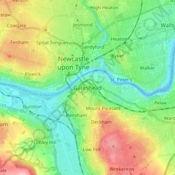
Nome: Mappa topografica Gateshead, altitudine, rilievo.

Luogo: Gateshead, Tyne and Wear, North East, England, NE8 1AG, United Kingdom (54.92258 -1.64193 55.00258 -1.56193)

Altitudine media: 62 m

Altitudine minima: -5 m

Altitudine massima: 184 m

Equipaggiati per la tua prossima avventura:

🕶️Occhiali Sole Categoria 4 - Lenti scurissime per protezione totale su ghiacciaio
🎯Strumenti di Orientamento - Set per orientarsi con mappe e bussola
📱Supporto Telefono per Manubrio - Supporto per telefono su mountain bike
🛶Tenda da Trekking - Tenda leggera per campeggio in montagna
🥾Calze Tecniche per Trekking - Calze traspiranti e antivesciche per lunghe camminate

In qualità di Affiliato Amazon, questo sito riceve una commissione sugli acquisti idonei, senza costi aggiuntivi per l’utente.