
Mappa topografica St Albans
Mappa interattiva
Clicca sulla mappa per visualizzare l'altitudine.
A proposito di questa mappa
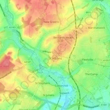
Nome: Mappa topografica St Albans, altitudine, rilievo.
Luogo: St Albans, Hertfordshire, England, United Kingdom (51.72913 -0.37529 51.78007 -0.29102)
Altitudine media: 103 m
Altitudine minima: 69 m
Altitudine massima: 141 m
The borough consisted of the ancient parish of St Albans (also known as the Abbey parish) and parts of the parishes of St Michael and St Peter. The borough was reformed by the Municipal Corporations Act 1835 to become a municipal borough, and the boundary was adjusted to additionally include part of the parish of St Stephen. On 28 August 1877 the borough gained city status, following the elevation of St Albans Abbey to become a cathedral. The boundary was also adjusted in 1877 to include part of the parish of Sandridge.
Altre mappe topografiche
Clicca su una mappa per visualizzarne la topografia, l'altitudine e il rilievo.
Stevenage
United Kingdom > England > Hertfordshire
Stevenage, Hertfordshire, England, United Kingdom
Altitudine media: 108 m
Hertsmere
United Kingdom > England > Hertfordshire
Hertsmere, Hertfordshire, England, United Kingdom
Altitudine media: 95 m
Old Town
United Kingdom > England > Hertfordshire > Dacorum
Old Town, Dacorum, Hertfordshire, England, HP1 3AF, United Kingdom
Altitudine media: 124 m
Pelham Gate
United Kingdom > England > Hertfordshire > East Hertfordshire
Pelham Gate, Brent Pelham, East Hertfordshire, Hertfordshire, England, SG9 0HL, United Kingdom
Altitudine media: 113 m
St Paul's Walden
United Kingdom > England > Hertfordshire > North Hertfordshire
St Paul's Walden, North Hertfordshire, Hertfordshire, England, United Kingdom
Altitudine media: 121 m
Home Wood
United Kingdom > England > Hertfordshire > St Albans > Sandridge
Home Wood, Marshalswick, Sandridge, St Albans, Hertfordshire, England, AL4 0XR, United Kingdom
Altitudine media: 90 m
St Albans
United Kingdom > England > Hertfordshire
St Albans, Hertfordshire, England, United Kingdom
Altitudine media: 107 m
Much Hadham
United Kingdom > England > Hertfordshire > East Hertfordshire
Much Hadham, East Hertfordshire, Hertfordshire, England, United Kingdom
Altitudine media: 80 m
Harpenden
United Kingdom > England > Hertfordshire > St Albans > Hatching Green
Harpenden, Hatching Green, St Albans, Hertfordshire, England, United Kingdom
Altitudine media: 119 m
Kinsbourne Green
United Kingdom > England > Hertfordshire > St Albans
Kinsbourne Green, Harpenden Rural, St Albans, Hertfordshire, England, AL5 3PJ, United Kingdom
Altitudine media: 134 m
Letchworth
United Kingdom > England > Hertfordshire
Letchworth, Hertfordshire, England, United Kingdom
Altitudine media: 81 m
Hemel Hempstead
United Kingdom > England > Hertfordshire > Dacorum
Hemel Hempstead, Dacorum, Hertfordshire, England, HP1 1EW, United Kingdom
Altitudine media: 130 m
Bishops Stortford Elsan Point
United Kingdom > England > Hertfordshire > East Hertfordshire
Bishops Stortford Elsan Point, East Hertfordshire, Hertfordshire, East of England, England, CM23 3BL, United Kingdom
Altitudine media: 78 m
Buntingford
United Kingdom > England > Hertfordshire > East Hertfordshire
Buntingford, East Hertfordshire, Hertfordshire, England, United Kingdom
Altitudine media: 110 m
Hitchin
United Kingdom > England > Hertfordshire > North Hertfordshire
Hitchin, North Hertfordshire, Hertfordshire, England, SG5 1BB, United Kingdom
Altitudine media: 91 m
Elstree
United Kingdom > England > Hertfordshire > Hertsmere > Elstree
Elstree, Hertsmere, Hertfordshire, East of England, England, WD6 3FE, United Kingdom
Altitudine media: 105 m
Thorley
United Kingdom > England > Hertfordshire > East Hertfordshire > Thorley
Thorley, East Hertfordshire, Hertfordshire, East of England, England, United Kingdom
Altitudine media: 82 m
Rounton
United Kingdom > England > Hertfordshire > Watford > Rounton
Rounton, Watford, Hertfordshire, East of England, England, WD17 4DU, United Kingdom
Altitudine media: 78 m
Bushey Heath
United Kingdom > England > Hertfordshire > Hertsmere > Bushey Heath
Bushey Heath, Hertsmere, Hertfordshire, East of England, England, WD23 1SH, United Kingdom
Altitudine media: 110 m
Hatfield
United Kingdom > England > Hertfordshire > Welwyn Hatfield
Hatfield, Welwyn Hatfield, Hertfordshire, England, United Kingdom
Altitudine media: 90 m
Barley
United Kingdom > England > Hertfordshire > North Hertfordshire
Barley, North Hertfordshire, Hertfordshire, England, United Kingdom
Altitudine media: 103 m
Watford
United Kingdom > England > Hertfordshire
Watford, Hertfordshire, England, United Kingdom
Altitudine media: 77 m
Welwyn
United Kingdom > England > Hertfordshire > Welwyn Hatfield > Oaklands
Welwyn, Oaklands, Welwyn Hatfield, Hertfordshire, England, United Kingdom
Altitudine media: 102 m
Welwyn Garden City
United Kingdom > England > Hertfordshire > Welwyn Hatfield
Welwyn Garden City, Welwyn Hatfield, Hertfordshire, England, AL8 6TP, United Kingdom
Altitudine media: 89 m
Berkhamsted
United Kingdom > England > Hertfordshire > Dacorum > Berkhamsted
Berkhamsted, Dacorum, Hertfordshire, England, United Kingdom
Altitudine media: 142 m
North Hertfordshire
United Kingdom > England > Hertfordshire
North Hertfordshire, Hertfordshire, England, United Kingdom
Altitudine media: 91 m
Bricket Wood
United Kingdom > England > Hertfordshire > St Albans
Bricket Wood, St Albans, Hertfordshire, England, AL2 3QS, United Kingdom
Altitudine media: 82 m
Therfield
United Kingdom > England > Hertfordshire > North Hertfordshire
Therfield, North Hertfordshire, Hertfordshire, England, United Kingdom
Altitudine media: 122 m