
Mappa topografica Norman
Mappa interattiva
Clicca sulla mappa per visualizzare l'altitudine.
A proposito di questa mappa
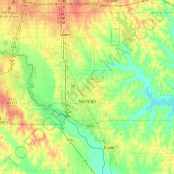
Nome: Mappa topografica Norman, altitudine, rilievo.
Luogo: Norman, Cleveland County, Oklahoma, United States (35.14532 -97.54745 35.34832 -97.17692)
Altitudine media: 358 m
Altitudine minima: 317 m
Altitudine massima: 432 m
Norman and the surrounding areas are mostly flat with an elevation near 1,171 ft (357 m). The terrain in the western section of Norman is prairie, while the eastern section, including the area surrounding Lake Thunderbird, consists of some 6,000 acres (24 km2) of lakes and Cross Timbers forest. The lowest point within city limits is approximately 970 ft (296 m) above sea level (located at 35.20388N, 97.17735W). The highest point is approximately 1,245 ft (379 m) above sea level (located at 35.21266N, 97.39000W).
Altre mappe topografiche
Clicca su una mappa per visualizzarne la topografia, l'altitudine e il rilievo.
Tom London Dam
United States > Oklahoma > Cleveland County
Tom London Dam, Cleveland County, Oklahoma, United States
Altitudine media: 324 m
Little Axe
United States > Oklahoma > Cleveland County > Norman
Little Axe, Norman, Cleveland County, Oklahoma, United States
Altitudine media: 321 m
Norman
United States > Oklahoma > Cleveland County > Norman
Norman, Cleveland County, Oklahoma, 73069, United States
Altitudine media: 356 m
Moore
United States > Oklahoma > Cleveland County > Moore > Moore
Moore, Cleveland County, Oklahoma, 73160, United States
Altitudine media: 377 m