
Fai una donazione
Equipaggiati per la tua prossima avventura:
In qualità di Affiliato Amazon, questo sito riceve una commissione sugli acquisti idonei, senza costi aggiuntivi per l’utente.
Mappa topografica Bath
Clicca sulla mappa per visualizzare l'altitudine.
Fai una donazione
Equipaggiati per la tua prossima avventura:
In qualità di Affiliato Amazon, questo sito riceve una commissione sugli acquisti idonei, senza costi aggiuntivi per l’utente.
Bath
Bath is also 100 miles (160 km) southwest of New York City and 60 miles (96 km) northwest of Philadelphia. It is also located near Wind Gap as well as the Delaware and Lehigh water gaps. Bath's elevation is 432 feet (132 m) above sea level as of 2011. The Borough is hilly and has many steep roads. There are two peaks in Bath, Hawk Mountain in the northeast, and Siegfried Hill in the southwest, which has been partially quarried out. Monocacy Creek, a tributary of the Lehigh River, flows through the town's center. The East Branch Monocacy also flows through Bath until their convergence further south. Other bodies of water include Penn-Dixie pond (the remains of a former quarry), the quarries at Keystone Cement, and numerous small ponds on the outskirts of town. Many mills operated using the flow of the Monocacy. Race and Mill street are named after them.
Fai una donazione
Equipaggiati per la tua prossima avventura:
In qualità di Affiliato Amazon, questo sito riceve una commissione sugli acquisti idonei, senza costi aggiuntivi per l’utente.
A proposito di questa mappa
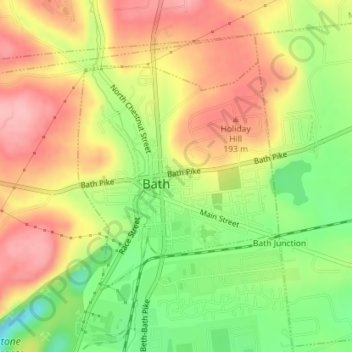
Nome: Mappa topografica Bath, altitudine, rilievo.
Luogo: Bath, Northampton County, Pennsylvania, United States (40.71836 -75.40142 40.73587 -75.38111)
Altitudine media: 152 m
Altitudine minima: 81 m
Altitudine massima: 212 m
Fai una donazione
Equipaggiati per la tua prossima avventura:
In qualità di Affiliato Amazon, questo sito riceve una commissione sugli acquisti idonei, senza costi aggiuntivi per l’utente.
Altre mappe topografiche
Clicca su una mappa per visualizzarne la topografia, l'altitudine e il rilievo.
Mount Bethel
United States > Pennsylvania > Northampton County > Upper Mount Bethel Township
Altitudine media: 156 m
Danielsville
United States > Pennsylvania > Northampton County > Lehigh Township
Altitudine media: 254 m
Portlamd Waterfront Park
United States > Pennsylvania > Northampton County > Portland
Altitudine media: 118 m
Fai una donazione
Equipaggiati per la tua prossima avventura:
In qualità di Affiliato Amazon, questo sito riceve una commissione sugli acquisti idonei, senza costi aggiuntivi per l’utente.
Kreidersville
United States > Pennsylvania > Northampton County > Allen Township
Altitudine media: 151 m
Morgan Hill
United States > Pennsylvania > Northampton County > Williams Township
Altitudine media: 147 m
Leithsville
United States > Pennsylvania > Northampton County > Lower Saucon Township
Altitudine media: 162 m
Fai una donazione
Equipaggiati per la tua prossima avventura:
In qualità di Affiliato Amazon, questo sito riceve una commissione sugli acquisti idonei, senza costi aggiuntivi per l’utente.
Illick's Mill Road Gateway
United States > Pennsylvania > Northampton County > Bethlehem
Altitudine media: 105 m
Mount Bethel
United States > Pennsylvania > Northampton County > Upper Mount Bethel Township
Altitudine media: 156 m
West Bangor
United States > Pennsylvania > Northampton County > Washington Township
Altitudine media: 310 m
Fai una donazione
Equipaggiati per la tua prossima avventura:
In qualità di Affiliato Amazon, questo sito riceve una commissione sugli acquisti idonei, senza costi aggiuntivi per l’utente.
Martins Creek
United States > Pennsylvania > Northampton County > Lower Mount Bethel Township
Altitudine media: 127 m
Weaversville
United States > Pennsylvania > Northampton County > East Allen Township
Altitudine media: 129 m
Fai una donazione
Equipaggiati per la tua prossima avventura:
In qualità di Affiliato Amazon, questo sito riceve una commissione sugli acquisti idonei, senza costi aggiuntivi per l’utente.
Northwood Heights
United States > Pennsylvania > Northampton County > Palmer Township > Palmer Heights
Altitudine media: 110 m
Brodhead
United States > Pennsylvania > Northampton County > Bethlehem Township
Altitudine media: 115 m
Fai una donazione
Equipaggiati per la tua prossima avventura:
In qualità di Affiliato Amazon, questo sito riceve una commissione sugli acquisti idonei, senza costi aggiuntivi per l’utente.