
Fai una donazione
Equipaggiati per la tua prossima avventura:
In qualità di Affiliato Amazon, questo sito riceve una commissione sugli acquisti idonei, senza costi aggiuntivi per l’utente.
Mappa topografica Thuvakudi
Clicca sulla mappa per visualizzare l'altitudine.
Fai una donazione
Equipaggiati per la tua prossima avventura:
In qualità di Affiliato Amazon, questo sito riceve una commissione sugli acquisti idonei, senza costi aggiuntivi per l’utente.
Thuvakudi
Thuvakudi is located at 10°45′23″N 78°48′04″E / 10.756389°N 78.801111°E / 10.756389; 78.801111. The average elevation is 88 metres (289 ft). The topology of Thuvakudi is almost flat with a few isolated hillocks rising above the surface. The city spread over an area of 14.371 square kilometres (5.549 sq mi) is situated between Tiruchirapalli and Thanjavur. Red soil is the most common type of soil, which is conducive for dry crops like chillies, cotton and groundnut. Thuvakudi is hot and dry for at least eight months of the year. The hottest months are from March to July during which the city experiences frequent dust storms. During this period, the days are extremely warm and dry while evenings are rendered cooler due to the cold winds that blow from the south-east. Thuvakudi experiences a moderate climate from August to October, tempered by heavy rain and thundershowers, and cool and balmy climate from November to February. Fog and dew are rare and occur only during the winter season. It receives an average annual rainfall of around 850 mm (33 in)
Fai una donazione
Equipaggiati per la tua prossima avventura:
In qualità di Affiliato Amazon, questo sito riceve una commissione sugli acquisti idonei, senza costi aggiuntivi per l’utente.
A proposito di questa mappa
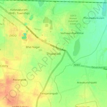
Nome: Mappa topografica Thuvakudi, altitudine, rilievo.
Altitudine media: 78 m
Altitudine minima: 58 m
Altitudine massima: 98 m
Fai una donazione
Equipaggiati per la tua prossima avventura:
In qualità di Affiliato Amazon, questo sito riceve una commissione sugli acquisti idonei, senza costi aggiuntivi per l’utente.