
Fai una donazione
Equipaggiati per la tua prossima avventura:
In qualità di Affiliato Amazon, questo sito riceve una commissione sugli acquisti idonei, senza costi aggiuntivi per l’utente.
Mappa topografica Daly City
Clicca sulla mappa per visualizzare l'altitudine.
Fai una donazione
Equipaggiati per la tua prossima avventura:
In qualità di Affiliato Amazon, questo sito riceve una commissione sugli acquisti idonei, senza costi aggiuntivi per l’utente.
Daly City
Several golf courses are located within or straddle the border with San Francisco. The Olympic Club has hosted the USGA U.S. Open five times, most recently in 2012, and will host both the 2028 PGA Championship and the 2032 Ryder Cup. The private San Francisco Golf Club and Lake Merced Golf Club have part or all of their course in Daly City. The Golden Gate National Recreation Area includes the city's Thornton Beach. The topography of this area (due to the San Andreas fault) is conducive to paragliding and hang gliding.
Fai una donazione
Equipaggiati per la tua prossima avventura:
In qualità di Affiliato Amazon, questo sito riceve una commissione sugli acquisti idonei, senza costi aggiuntivi per l’utente.
A proposito di questa mappa
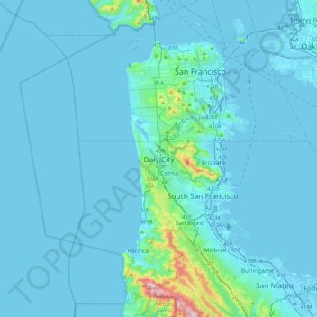
Nome: Mappa topografica Daly City, altitudine, rilievo.
Altitudine media: 32 m
Altitudine minima: -6 m
Altitudine massima: 567 m
Fai una donazione
Equipaggiati per la tua prossima avventura:
In qualità di Affiliato Amazon, questo sito riceve una commissione sugli acquisti idonei, senza costi aggiuntivi per l’utente.
Altre mappe topografiche
Clicca su una mappa per visualizzarne la topografia, l'altitudine e il rilievo.
Bayshore Heights Park
United States > California > San Mateo County > Daly City
Altitudine media: 84 m