
Mappa topografica Mullingar
Clicca sulla mappa per visualizzare l'altitudine.
A proposito di questa mappa
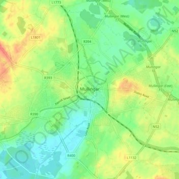
Nome: Mappa topografica Mullingar, altitudine, rilievo.
Altitudine media: 99 m
Altitudine minima: 79 m
Altitudine massima: 126 m
Altre mappe topografiche
Clicca su una mappa per visualizzarne la topografia, l'altitudine e il rilievo.
Lough Lene
The lake is described in Samuel Lewis's Topographical Dictionary of Ireland (1837) as being an irregular oval shape, possibly 3.2 km (2.0 mi) long by 1.7 km (1.1 mi) broad. A fresh water lake, most sources focus on the clarity of the water, with the term "gin clear" being used to describe it. It sits…
Altitudine media: 109 m