
Mappa topografica Village of Rhinebeck
Mappa interattiva
Clicca sulla mappa per visualizzare l'altitudine.
A proposito di questa mappa
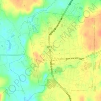
Nome: Mappa topografica Village of Rhinebeck, altitudine, rilievo.
Altitudine media: 55 m
Altitudine minima: 33 m
Altitudine massima: 74 m
Altre mappe topografiche
Clicca su una mappa per visualizzarne la topografia, l'altitudine e il rilievo.
Hurd Corners
United States > New York > Dutchess County > Town of Pawling
Hurd Corners, Town of Pawling, Dutchess County, New York, 12564, United States
Altitudine media: 199 m
Town of Rhinebeck
United States > New York > Dutchess County > Town of Rhinebeck
Town of Rhinebeck, Dutchess County, New York, United States
Altitudine media: 66 m
Beacon
United States > New York > Dutchess County > Beacon > Beacon
Beacon, Dutchess County, New York, 12508, United States
Altitudine media: 91 m
Poughquag
United States > New York > Dutchess County > Beekman > Poughquag
Poughquag, Beekman, Town of Beekman, Dutchess County, New York, 12570, United States
Altitudine media: 164 m
Pawling Nature Reserve
United States > New York > Dutchess County
Pawling Nature Reserve, Town of Dover, Dutchess County, New York, United States
Altitudine media: 252 m