
Fai una donazione
Equipaggiati per la tua prossima avventura:
In qualità di Affiliato Amazon, questo sito riceve una commissione sugli acquisti idonei, senza costi aggiuntivi per l’utente.
Mappa topografica Richmond County
Clicca sulla mappa per visualizzare l'altitudine.
Fai una donazione
Equipaggiati per la tua prossima avventura:
In qualità di Affiliato Amazon, questo sito riceve una commissione sugli acquisti idonei, senza costi aggiuntivi per l’utente.
Richmond County
The highest point on the island, the summit of Todt Hill, elevation 401 ft (122 m), is also the highest point in the five boroughs, as well as the highest point on the Atlantic coastal plain south of Great Blue Hill in Massachusetts and the highest point on the coast proper south of Maine's Camden Hills. Ward's Point in the neighborhood of Tottenville is the southernmost point in the state of New York.
Fai una donazione
Equipaggiati per la tua prossima avventura:
In qualità di Affiliato Amazon, questo sito riceve una commissione sugli acquisti idonei, senza costi aggiuntivi per l’utente.
A proposito di questa mappa
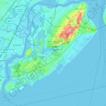
Nome: Mappa topografica Richmond County, altitudine, rilievo.
Luogo: Richmond County, New York, United States (40.47658 -74.25884 40.65151 -74.03461)
Altitudine media: 9 m
Altitudine minima: -5 m
Altitudine massima: 121 m
Fai una donazione
Equipaggiati per la tua prossima avventura:
In qualità di Affiliato Amazon, questo sito riceve una commissione sugli acquisti idonei, senza costi aggiuntivi per l’utente.
Altre mappe topografiche
Clicca su una mappa per visualizzarne la topografia, l'altitudine e il rilievo.
Fai una donazione
Equipaggiati per la tua prossima avventura:
In qualità di Affiliato Amazon, questo sito riceve una commissione sugli acquisti idonei, senza costi aggiuntivi per l’utente.
Flushing Meadows-Corona Park
United States > New York > New York
Around 1907, contractor Michael Degnon, whose firm constructed the Williamsburg Bridge, the Cape Cod Canal, and the Steinway subway tunnel (used by today's 7 and <7> trains), purchased large tracts of marsh near Flushing Creek. At the time, the land was considered "all but worthless". Degnon envisioned…
Altitudine media: 15 m
Fai una donazione
Equipaggiati per la tua prossima avventura:
In qualità di Affiliato Amazon, questo sito riceve una commissione sugli acquisti idonei, senza costi aggiuntivi per l’utente.
Fai una donazione
Equipaggiati per la tua prossima avventura:
In qualità di Affiliato Amazon, questo sito riceve una commissione sugli acquisti idonei, senza costi aggiuntivi per l’utente.
Fai una donazione
Equipaggiati per la tua prossima avventura:
In qualità di Affiliato Amazon, questo sito riceve una commissione sugli acquisti idonei, senza costi aggiuntivi per l’utente.
Fai una donazione
Equipaggiati per la tua prossima avventura:
In qualità di Affiliato Amazon, questo sito riceve una commissione sugli acquisti idonei, senza costi aggiuntivi per l’utente.