
Fai una donazione
Equipaggiati per la tua prossima avventura:
In qualità di Affiliato Amazon, questo sito riceve una commissione sugli acquisti idonei, senza costi aggiuntivi per l’utente.
Mappa topografica Star Valley
Clicca sulla mappa per visualizzare l'altitudine.
Fai una donazione
Equipaggiati per la tua prossima avventura:
In qualità di Affiliato Amazon, questo sito riceve una commissione sugli acquisti idonei, senza costi aggiuntivi per l’utente.
Star Valley
According to the United States Census Bureau, the town has a total area of 36.1 square miles (93.6 km2), of which 0.01 square miles (0.02 km2), or 0.03%, is water. Star Valley sits at an elevation of 4,650 feet (1,420 m) and takes its name from the valley in which it is located, formed by Houston Creek, which descends to the south through Tonto National Forest to Tonto Creek, a tributary of the Salt River. The town was incorporated as the Town of Diamond Star, but changed its name to Star Valley in 2006.
Fai una donazione
Equipaggiati per la tua prossima avventura:
In qualità di Affiliato Amazon, questo sito riceve una commissione sugli acquisti idonei, senza costi aggiuntivi per l’utente.
A proposito di questa mappa
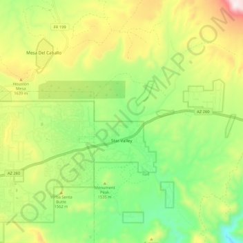
Nome: Mappa topografica Star Valley, altitudine, rilievo.
Luogo: Star Valley, Gila County, Arizona, United States (34.21713 -111.27992 34.30436 -111.20321)
Altitudine media: 1’521 m
Altitudine minima: 1’221 m
Altitudine massima: 1’933 m
Fai una donazione
Equipaggiati per la tua prossima avventura:
In qualità di Affiliato Amazon, questo sito riceve una commissione sugli acquisti idonei, senza costi aggiuntivi per l’utente.