
Fai una donazione
Equipaggiati per la tua prossima avventura:
In qualità di Affiliato Amazon, questo sito riceve una commissione sugli acquisti idonei, senza costi aggiuntivi per l’utente.
Mappa topografica Linglestown
Clicca sulla mappa per visualizzare l'altitudine.
Fai una donazione
Equipaggiati per la tua prossima avventura:
In qualità di Affiliato Amazon, questo sito riceve una commissione sugli acquisti idonei, senza costi aggiuntivi per l’utente.
Linglestown
The highest elevation is 995 feet (303 m) on the south slope of Blue Mountain, along Blue Mountain Parkway north of the center of town. Pennsylvania Route 39 (Linglestown Road) passes east-to-west through the village, leading east 3.5 miles (5.6 km) to Exit 77 on Interstate 81 and west 5 miles (8 km) to Highway 22-322 at the north end of Harrisburg.
Fai una donazione
Equipaggiati per la tua prossima avventura:
In qualità di Affiliato Amazon, questo sito riceve una commissione sugli acquisti idonei, senza costi aggiuntivi per l’utente.
A proposito di questa mappa
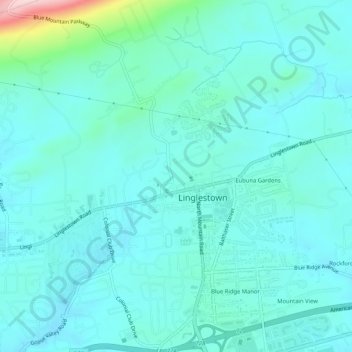
Nome: Mappa topografica Linglestown, altitudine, rilievo.
Altitudine media: 161 m
Altitudine minima: 124 m
Altitudine massima: 376 m
Fai una donazione
Equipaggiati per la tua prossima avventura:
In qualità di Affiliato Amazon, questo sito riceve una commissione sugli acquisti idonei, senza costi aggiuntivi per l’utente.