
Fai una donazione
Equipaggiati per la tua prossima avventura:
In qualità di Affiliato Amazon, questo sito riceve una commissione sugli acquisti idonei, senza costi aggiuntivi per l’utente.
Mappa topografica Lake San Cristobal
Clicca sulla mappa per visualizzare l'altitudine.
Fai una donazione
Equipaggiati per la tua prossima avventura:
In qualità di Affiliato Amazon, questo sito riceve una commissione sugli acquisti idonei, senza costi aggiuntivi per l’utente.
Lake San Cristobal
Lake San Cristobal is a lake in the U.S. state of Colorado. Located in the San Juan Mountains at an elevation of 9,003 feet (2,744 m), the freshwater lake is 2.1 miles (3.4 km) long, up to 89 feet (27 m) deep, has a surface area of 0.52 square miles (1.3 km2), and holds about 11,000 acre-feet (14,000,000 m3) of water. The town of Lake City, a few miles to the north, is named after Lake San Cristobal. The name San Cristóbal means Saint Christopher in the Spanish language. Many old silver mines are near the lake and it is very clean and well kept, and stocked with Rainbow Trout.
Fai una donazione
Equipaggiati per la tua prossima avventura:
In qualità di Affiliato Amazon, questo sito riceve una commissione sugli acquisti idonei, senza costi aggiuntivi per l’utente.
A proposito di questa mappa
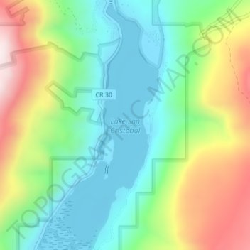
Nome: Mappa topografica Lake San Cristobal, altitudine, rilievo.
Altitudine media: 2’947 m
Altitudine minima: 2’744 m
Altitudine massima: 3’326 m
Fai una donazione
Equipaggiati per la tua prossima avventura:
In qualità di Affiliato Amazon, questo sito riceve una commissione sugli acquisti idonei, senza costi aggiuntivi per l’utente.
Altre mappe topografiche
Clicca su una mappa per visualizzarne la topografia, l'altitudine e il rilievo.
Fai una donazione
Equipaggiati per la tua prossima avventura:
In qualità di Affiliato Amazon, questo sito riceve una commissione sugli acquisti idonei, senza costi aggiuntivi per l’utente.