
Fai una donazione
Equipaggiati per la tua prossima avventura:
In qualità di Affiliato Amazon, questo sito riceve una commissione sugli acquisti idonei, senza costi aggiuntivi per l’utente.
Mappa topografica Gresham
Clicca sulla mappa per visualizzare l'altitudine.
Fai una donazione
Equipaggiati per la tua prossima avventura:
In qualità di Affiliato Amazon, questo sito riceve una commissione sugli acquisti idonei, senza costi aggiuntivi per l’utente.
Gresham
Though much of Gresham is relatively flat, it is characterized by a hill on its eastern border. Northeast Gresham is also hilly, particularly where the city meets Troutdale toward the Columbia River. Its elevation is 325 feet (99 m). Johnson Creek, which begins at the foothills of the Cascade Mountains, runs westward through Gresham, with 23 percent of the creek's watershed running through the city.
Fai una donazione
Equipaggiati per la tua prossima avventura:
In qualità di Affiliato Amazon, questo sito riceve una commissione sugli acquisti idonei, senza costi aggiuntivi per l’utente.
A proposito di questa mappa
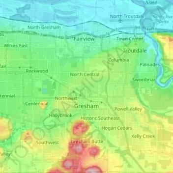
Nome: Mappa topografica Gresham, altitudine, rilievo.
Luogo: Gresham, Multnomah County, Oregon, United States (45.46094 -122.49807 45.56088 -122.36758)
Altitudine media: 90 m
Altitudine minima: -2 m
Altitudine massima: 322 m
Fai una donazione
Equipaggiati per la tua prossima avventura:
In qualità di Affiliato Amazon, questo sito riceve una commissione sugli acquisti idonei, senza costi aggiuntivi per l’utente.
Altre mappe topografiche
Clicca su una mappa per visualizzarne la topografia, l'altitudine e il rilievo.
Rocky Butte
United States > Oregon > Multnomah County > Portland
Rocky Butte lies in the northeast part of Portland within the city limits, in Multnomah County, part of the U. S. state of Oregon. It is one of the few smaller volcanic cones within or near Portland, along with Mount Tabor, Kelly Butte, and Powell Butte. According to the U.S. National Geodetic Survey, Rocky…
Altitudine media: 67 m
Fai una donazione
Equipaggiati per la tua prossima avventura:
In qualità di Affiliato Amazon, questo sito riceve una commissione sugli acquisti idonei, senza costi aggiuntivi per l’utente.
Fai una donazione
Equipaggiati per la tua prossima avventura:
In qualità di Affiliato Amazon, questo sito riceve una commissione sugli acquisti idonei, senza costi aggiuntivi per l’utente.
Governor Tom McCall Waterfront Park
United States > Oregon > Multnomah County > Portland
Altitudine media: 26 m
Fai una donazione
Equipaggiati per la tua prossima avventura:
In qualità di Affiliato Amazon, questo sito riceve una commissione sugli acquisti idonei, senza costi aggiuntivi per l’utente.
Fai una donazione
Equipaggiati per la tua prossima avventura:
In qualità di Affiliato Amazon, questo sito riceve una commissione sugli acquisti idonei, senza costi aggiuntivi per l’utente.