
Mappa topografica Town of Watertown
Mappa interattiva
Clicca sulla mappa per visualizzare l'altitudine.
A proposito di questa mappa
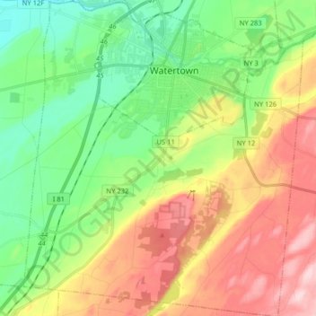
Nome: Mappa topografica Town of Watertown, altitudine, rilievo.
Luogo: Town of Watertown, Jefferson County, New York, United States (43.88506 -75.98706 44.00025 -75.84560)
Altitudine media: 189 m
Altitudine minima: 87 m
Altitudine massima: 340 m
Altre mappe topografiche
Clicca su una mappa per visualizzarne la topografia, l'altitudine e il rilievo.
Village of Evans Mills
United States > New York > Jefferson County
Village of Evans Mills, Town of Le Ray, Jefferson County, New York, United States
Altitudine media: 139 m
Just Room Enough Island
United States > New York > Jefferson County > Village of Alexandria Bay
Just Room Enough Island, Village of Alexandria Bay, Town of Alexandria, Jefferson County, New York, United States
Altitudine media: 78 m
Village of Black River
United States > New York > Jefferson County
Village of Black River, Town of Le Ray, Jefferson County, New York, United States
Altitudine media: 193 m
Village of Philadelphia
United States > New York > Jefferson County
Village of Philadelphia, Town of Philadelphia, Jefferson County, New York, 13673, United States
Altitudine media: 149 m
Village of Theresa
United States > New York > Jefferson County > Town of Theresa
Village of Theresa, Town of Theresa, Jefferson County, New York, 13691, United States
Altitudine media: 121 m
Black River
United States > New York > Jefferson County > Black River
Black River, Le Ray, Jefferson County, New York, 13612, United States
Altitudine media: 189 m
Whites Bay
United States > New York > Jefferson County
Whites Bay, Henderson, Jefferson County, New York, 13651, United States
Altitudine media: 91 m