
Mappa topografica Rocester
Clicca sulla mappa per visualizzare l'altitudine.
A proposito di questa mappa
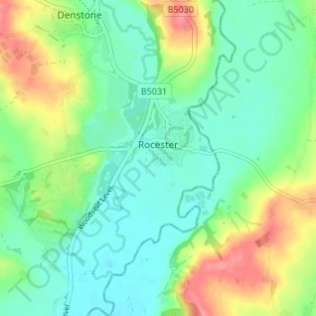
Nome: Mappa topografica Rocester, altitudine, rilievo.
Altitudine media: 105 m
Altitudine minima: 79 m
Altitudine massima: 156 m
Altre mappe topografiche
Clicca su una mappa per visualizzarne la topografia, l'altitudine e il rilievo.
Tutbury Castle
United Kingdom > England > Staffordshire > East Staffordshire > Tutbury
Altitudine media: 66 m
Burton upon Trent
United Kingdom > England > Staffordshire > East Staffordshire
Burton is about 109 miles (175 km) north west of London, about 30 miles north east of Birmingham, the UK's second largest city and about 23 miles east of the county town Stafford. It is at the easternmost border of the county of Staffordshire with Derbyshire, its suburbs and the course of the River Trent…
Altitudine media: 69 m
Stubwood
United Kingdom > England > Staffordshire > East Staffordshire > Denstone
Altitudine media: 113 m
Birch Cross
United Kingdom > England > Staffordshire > East Staffordshire > Marchington
Altitudine media: 92 m
Blithfield Reservoir
United Kingdom > England > Staffordshire > East Staffordshire > Admaston
Altitudine media: 108 m
Gratwich
United Kingdom > England > Staffordshire > East Staffordshire > Kingstone
Altitudine media: 143 m
Marchington Woodlands
United Kingdom > England > Staffordshire > East Staffordshire
Altitudine media: 120 m
Harlow Wood
United Kingdom > England > Staffordshire > East Staffordshire > Upper Mayfield
Altitudine media: 177 m
Burton upon Trent
United Kingdom > England > Staffordshire > East Staffordshire
Burton is about 109 miles (175 km) north west of London, about 30 miles north east of Birmingham, the UK's second largest city and about 23 miles east of the county town Stafford. It is at the easternmost border of the county of Staffordshire with Derbyshire, its suburbs and the course of the River Trent…
Altitudine media: 69 m