
Mappa topografica Culebra
Mappa interattiva
Clicca sulla mappa per visualizzare l'altitudine.
A proposito di questa mappa
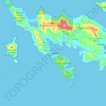
Nome: Mappa topografica Culebra, altitudine, rilievo.
Luogo: Culebra, Puerto Rico, 00775-0969, United States (18.26305 -65.34010 18.34305 -65.26010)
Altitudine media: 16 m
Altitudine minima: -3 m
Altitudine massima: 188 m
Culebra is characterized by an irregular topography resulting in a long intricate shoreline. The island is approximately 7 by 5 miles (11 by 8 km). The coast is marked by cliffs, sandy coral beaches and mangrove forests. Inland, the tallest point on the island is Mount Resaca, with an elevation of 636 ft (193.9 m), followed by Balcón Hill, with an elevation of 545 ft (166.1 m).