
Mappa topografica Townsend
Mappa interattiva
Clicca sulla mappa per visualizzare l'altitudine.
A proposito di questa mappa
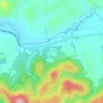
Nome: Mappa topografica Townsend, altitudine, rilievo.
Luogo: Townsend, Blount County, Tennessee, United States (35.66323 -83.76812 35.68483 -83.73249)
Altitudine media: 376 m
Altitudine minima: 305 m
Altitudine massima: 582 m
Just to the north and west of Townsend, the Foothills Parkway is a national parkway that traverses Chilhowee Mountain and offers multiple scenic overlooks at high elevations, with views of the Smokies to the south and the Tennessee Valley and Cumberland Plateau to the north and west. As of 2016, road construction on the parkway to complete the "missing link" from Walland to Wears Valley can be seen from Townsend during the mid-day and afternoon. This section eventually opened in late 2018, more than half a century after the first section opened in 1966.