
Mappa topografica Mieres
Mappa interattiva
Clicca sulla mappa per visualizzare l'altitudine.
Mieres
Mieres is the heart of the coal mining industry in Spain. The topography of Mieres is mountainous with the greatest population centers being located in the valley along the banks of the Caudal River (Río Caudal) valley in the center of Asturias. Before the Spanish Industrial Restructuring Mieres was one of the industrial backbones of Asturias, and hosted 70000 inhabitants in the 1960s. Today Mieres shelters a campus of the University of Oviedo and different museums in relation with the industrial heritage.
A proposito di questa mappa
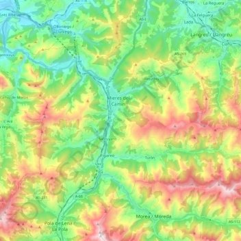
Nome: Mappa topografica Mieres, altitudine, rilievo.
Luogo: Mieres, Asturias, Spain (43.18111 -5.85553 43.28914 -5.62549)
Altitudine media: 498 m
Altitudine minima: 116 m
Altitudine massima: 1’171 m
Altre mappe topografiche
Clicca su una mappa per visualizzarne la topografia, l'altitudine e il rilievo.
Picos de Europa
The Picos de Europa ("Peaks of Europe", also the Picos) are a mountain range extending for about 20 km (12 mi), forming part of the Cantabrian Mountains in northern Spain. The range is situated in the Autonomous Communities of Asturias, Cantabria and Castile and León. The highest peak is Torre de Cerredo, at…
Altitudine media: 2’290 m