
Mappa topografica Hot Springs National Park
Mappa interattiva
Clicca sulla mappa per visualizzare l'altitudine.
A proposito di questa mappa
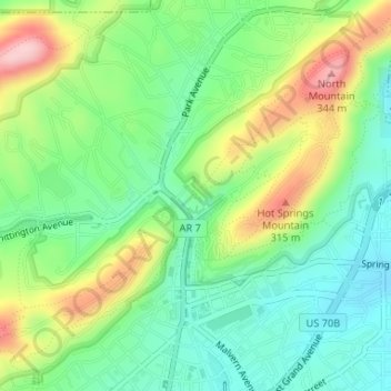
Nome: Mappa topografica Hot Springs National Park, altitudine, rilievo.
Altitudine media: 227 m
Altitudine minima: 158 m
Altitudine massima: 346 m
The National Park Service exercises no control or supervision over any matters connected with the city. The city starts on the other side of Central Avenue from Bathhouse Row. Its development has extended beyond the narrow valley in which the springs are located, spreading out over the open plain to the south and east. The climate is good throughout the year. The elevation of the city is 600 feet (180 m) above sea level, with surrounding hills rising another 600 feet. In the first half of the 20th century, the city operated primarily as a summer resort, but hotels have now long stayed open during the winter due to many northerly patrons coming to escape the winter cold.
Altre mappe topografiche
Clicca su una mappa per visualizzarne la topografia, l'altitudine e il rilievo.
Piney
United States > Arkansas > Garland County > Hot Springs
Piney, Hot Springs, Garland County, Arkansas, United States
Altitudine media: 146 m
Lake Hamilton
United States > Arkansas > Garland County > Hot Springs
Lake Hamilton, Hot Springs, Garland County, Arkansas, United States
Altitudine media: 130 m
Hot Springs
United States > Arkansas > Garland County > Hot Springs
Hot Springs, Garland County, Arkansas, 71901, United States
Altitudine media: 187 m