
Mappa topografica Big Bend National Park
Mappa interattiva
Clicca sulla mappa per visualizzare l'altitudine.
A proposito di questa mappa
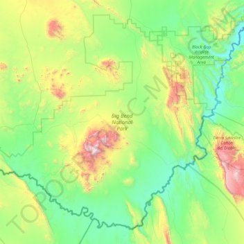
Nome: Mappa topografica Big Bend National Park, altitudine, rilievo.
Altitudine media: 934 m
Altitudine minima: 490 m
Altitudine massima: 2’330 m
Big Bend National Park is an American national park located in West Texas, bordering Mexico. The park has national significance as the largest protected area of Chihuahuan Desert topography and ecology in the United States, and was named after a large bend in the Rio Grande/Río Bravo. The park protects more than 1,200 species of plants, more than 450 species of birds, 56 species of reptiles, and 75 species of mammals. Additional park activities include scenic drives, programs led by Big Bend park rangers, and stargazing.
Altre mappe topografiche
Clicca su una mappa per visualizzarne la topografia, l'altitudine e il rilievo.
Big Bend National Park
United States > Texas > Brewster County
Big Bend National Park, Brewster County, Texas, 79834, United States
Altitudine media: 934 m
Santiago Peak
United States > Texas > Brewster County
Santiago Peak, Brewster County, Texas, United States
Altitudine media: 1’525 m
Alpine
United States > Texas > Brewster County
Alpine, Brewster County, Texas, United States
Altitudine media: 1’373 m