
Mappa topografica Jersey City
Mappa interattiva
Clicca sulla mappa per visualizzare l'altitudine.
A proposito di questa mappa
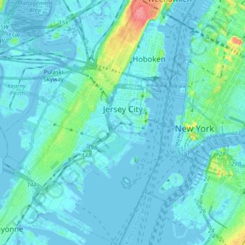
Nome: Mappa topografica Jersey City, altitudine, rilievo.
Luogo: Jersey City, Hudson County, New Jersey, United States (40.66162 -74.11669 40.76894 -74.02064)
Altitudine media: 9 m
Altitudine minima: -8 m
Altitudine massima: 80 m
Jersey City (and most of Hudson County) is located on the peninsula known as Bergen Neck, with a waterfront on the east at the Hudson River and New York Bay and on the west at the Hackensack River and Newark Bay. Its north–south axis corresponds with the ridge of Bergen Hill, the emergence of the Hudson Palisades. The city is the site of some of the earliest European settlements in North America, which grew into each other rather than expanding from a central point. This growth and the topography greatly influenced the development of the sections of the city and its various neighborhoods.
Altre mappe topografiche
Clicca su una mappa per visualizzarne la topografia, l'altitudine e il rilievo.
Secaucus
United States > New Jersey > Hudson County
Secaucus, Hudson County, New Jersey, United States
Altitudine media: 13 m
Hoboken
United States > New Jersey > Hudson County
Hoboken, Hudson County, New Jersey, United States
Altitudine media: 14 m
Jersey City
United States > New Jersey > Hudson County > Jersey City
Jersey City, Hudson County, New Jersey, 07302, United States
Altitudine media: 21 m