
Fai una donazione
Equipaggiati per la tua prossima avventura:
In qualità di Affiliato Amazon, questo sito riceve una commissione sugli acquisti idonei, senza costi aggiuntivi per l’utente.
Mappa topografica Thengapattinam
Clicca sulla mappa per visualizzare l'altitudine.
Fai una donazione
Equipaggiati per la tua prossima avventura:
In qualità di Affiliato Amazon, questo sito riceve una commissione sugli acquisti idonei, senza costi aggiuntivi per l’utente.
Thengapattinam
Thengapattanam is located in the South western coast of India bordering the Arabian Sea to the west, western ghats to the north, and vast fertile plains with intermittent Rocky hills to the east. The town is 11 km into the Tamil Nadu border from Kerala. The Kerala state capital Thiruvananthapuram is 45 km away from here, whereas Nagercoil is 35 km away. It shares borders with Erayumanthurai, and Amsi villages on either side. The mean elevation of the town is 9 ft (2.7 m) with the highest point Chentapalli Rock being 50 ft (15 m) high above sea level. The Thamirabarani River wraps around most parts of the Kanyakumari district and becomes Kuzhithurai River before reaching Thengapattanam Estuary.
Fai una donazione
Equipaggiati per la tua prossima avventura:
In qualità di Affiliato Amazon, questo sito riceve una commissione sugli acquisti idonei, senza costi aggiuntivi per l’utente.
A proposito di questa mappa
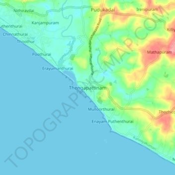
Nome: Mappa topografica Thengapattinam, altitudine, rilievo.
Altitudine media: 17 m
Altitudine minima: -1 m
Altitudine massima: 86 m
Fai una donazione
Equipaggiati per la tua prossima avventura:
In qualità di Affiliato Amazon, questo sito riceve una commissione sugli acquisti idonei, senza costi aggiuntivi per l’utente.