
Mappa topografica St Albans
Clicca sulla mappa per visualizzare l'altitudine.
St Albans
The borough consisted of the ancient parish of St Albans (also known as the Abbey parish) and parts of the parishes of St Michael and St Peter. The borough was reformed by the Municipal Corporations Act 1835 to become a municipal borough, and the boundary was adjusted to additionally include part of the parish of St Stephen. On 28 August 1877 the borough gained city status, following the elevation of St Albans Abbey to become a cathedral. The boundary was also adjusted in 1877 to include part of the parish of Sandridge.
A proposito di questa mappa
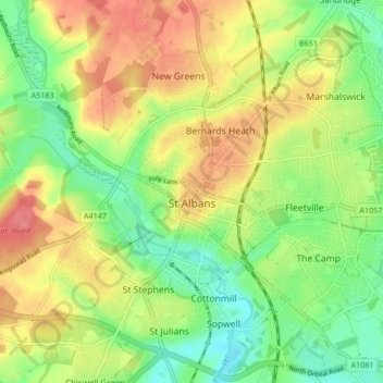
Nome: Mappa topografica St Albans, altitudine, rilievo.
Luogo: St Albans, Hertfordshire, England, United Kingdom (51.72913 -0.37529 51.78007 -0.29102)
Altitudine media: 103 m
Altitudine minima: 69 m
Altitudine massima: 141 m
Altre mappe topografiche
Clicca su una mappa per visualizzarne la topografia, l'altitudine e il rilievo.
St Albans
United Kingdom > England > Hertfordshire > St Albans
St Albans was an ancient borough created following the dissolution of the monastery in 1539. It consisted of the ancient parish of St Albans (also known as the Abbey parish) and parts of St Michael and St Peter. The municipal corporation was reformed by the Municipal Corporations Act 1835 and the boundary was…
Altitudine media: 100 m
Elstree
United Kingdom > England > Hertfordshire > Hertsmere
In 1723, topographer John Norden noted in his book Speculum Britanniae, that in the county of Hartfordshire [sic] was one "Elstre or Eglestre". In an earlier edition, he writes.
Altitudine media: 105 m
Spellbrook
United Kingdom > England > Hertfordshire > East Hertfordshire > Sawbridgeworth
Altitudine media: 71 m
Highfield Park
United Kingdom > England > Hertfordshire > St Albans > Colney Heath
Altitudine media: 87 m
Letchworth
United Kingdom > England > Hertfordshire > North Hertfordshire > Letchworth
Altitudine media: 80 m
Astonbury Wood
United Kingdom > England > Hertfordshire > East Hertfordshire > Aston
Altitudine media: 83 m
Ashbrook
United Kingdom > England > Hertfordshire > North Hertfordshire > St Ippolyts
Altitudine media: 85 m
Waterford
United Kingdom > England > Hertfordshire > East Hertfordshire > Waterford
Altitudine media: 66 m
Ellenbrook Fields
United Kingdom > England > Hertfordshire > Welwyn Hatfield > Hatfield
Altitudine media: 80 m
Windmill Hill
United Kingdom > England > Hertfordshire > North Hertfordshire > Hitchin
Altitudine media: 74 m
Primrosehill
United Kingdom > England > Hertfordshire > Three Rivers > Abbots Langley
Altitudine media: 111 m
Saint Margarets Copse
United Kingdom > England > Hertfordshire > Dacorum > Great Gaddesden
Altitudine media: 144 m
Mardley Heath
United Kingdom > England > Hertfordshire > Welwyn Hatfield > Oaklands
Altitudine media: 110 m
Throcking
United Kingdom > England > Hertfordshire > East Hertfordshire > Buntingford
Altitudine media: 126 m
Hammerfield
United Kingdom > England > Hertfordshire > Dacorum > Hemel Hempstead
Altitudine media: 122 m
Temple Dinsley
United Kingdom > England > Hertfordshire > North Hertfordshire > Preston
Altitudine media: 124 m
Bendish
United Kingdom > England > Hertfordshire > North Hertfordshire > Breachwood Green
Altitudine media: 128 m
Gobions Pond
United Kingdom > England > Hertfordshire > Welwyn Hatfield > Brookmans Park > Swanley Bar
Altitudine media: 106 m
Blackmore End
United Kingdom > England > Hertfordshire > St Albans > Wheathampstead
Altitudine media: 114 m
Tewin Wood
United Kingdom > England > Hertfordshire > East Hertfordshire > Burnham Green
Altitudine media: 101 m
Tringford Reservoir
United Kingdom > England > Hertfordshire > Dacorum > Tring > Wilstone
Altitudine media: 119 m
Knebworth Country Park
United Kingdom > England > Hertfordshire > North Hertfordshire > Knebworth
Altitudine media: 116 m
Chapmore End
United Kingdom > England > Hertfordshire > East Hertfordshire > Tonwell
Altitudine media: 65 m
Stanstead St Margarets
United Kingdom > England > Hertfordshire > East Hertfordshire
Altitudine media: 48 m
Hadham Cross
United Kingdom > England > Hertfordshire > East Hertfordshire > Much Hadham
Altitudine media: 79 m
Thorley Street
United Kingdom > England > Hertfordshire > East Hertfordshire > Thorley
Altitudine media: 74 m
Peter's Green
United Kingdom > England > Hertfordshire > North Hertfordshire > Kimpton
Altitudine media: 133 m
Pimlico
United Kingdom > England > Hertfordshire > Three Rivers > Abbots Langley
Altitudine media: 123 m
The Rookery
United Kingdom > England > Hertfordshire > Three Rivers > Abbots Langley > Langleybury
Altitudine media: 92 m
Dixon's Gap Bridge
United Kingdom > England > Hertfordshire > Dacorum > Wilstone > Gubblecote
Altitudine media: 101 m
Whempstead
United Kingdom > England > Hertfordshire > East Hertfordshire > Dane End
Altitudine media: 95 m
Stanborough Park
United Kingdom > England > Hertfordshire > Welwyn Hatfield > Hatfield > Stanborough
Altitudine media: 79 m
Sarratt Bottom
United Kingdom > England > Hertfordshire > Three Rivers > Sarratt
Altitudine media: 112 m
Bushey
United Kingdom > England > Hertfordshire > Hertsmere
Bushey is a town in the Hertsmere borough of Hertfordshire in the East of England. It had a population of 25,328 in the 2011 census, rising to 28,416 in the 2021 census, an increase of 12.19%. This makes Bushey the second most populated town in Hertsmere. Bushey Heath is a large neighbourhood south east of…
Altitudine media: 88 m
Bentley Heath
United Kingdom > England > Hertfordshire > Hertsmere > Potters Bar
Altitudine media: 105 m