
Fai una donazione
Equipaggiati per la tua prossima avventura:
In qualità di Affiliato Amazon, questo sito riceve una commissione sugli acquisti idonei, senza costi aggiuntivi per l’utente.
Mappa topografica Traverse City
Clicca sulla mappa per visualizzare l'altitudine.
Fai una donazione
Equipaggiati per la tua prossima avventura:
In qualità di Affiliato Amazon, questo sito riceve una commissione sugli acquisti idonei, senza costi aggiuntivi per l’utente.
Traverse City
The locale and topography is conducive for road bicycling, aided by the TART trail system. A map with routes, different trips, advice and local knowledge is available. Lake Michigan presents a location for sailing, fishing, and kayaking.
Fai una donazione
Equipaggiati per la tua prossima avventura:
In qualità di Affiliato Amazon, questo sito riceve una commissione sugli acquisti idonei, senza costi aggiuntivi per l’utente.
A proposito di questa mappa
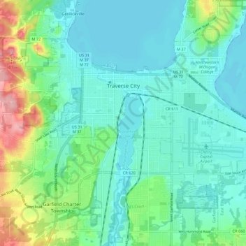
Nome: Mappa topografica Traverse City, altitudine, rilievo.
Altitudine media: 204 m
Altitudine minima: 174 m
Altitudine massima: 307 m
Fai una donazione
Equipaggiati per la tua prossima avventura:
In qualità di Affiliato Amazon, questo sito riceve una commissione sugli acquisti idonei, senza costi aggiuntivi per l’utente.
Altre mappe topografiche
Clicca su una mappa per visualizzarne la topografia, l'altitudine e il rilievo.
Lookout Point
United States > Michigan > Grand Traverse County > Peninsula Township
Altitudine media: 188 m
Old Mission
United States > Michigan > Grand Traverse County
Old Mission is located just east of M-37 near the tip of Old Mission Peninsula about 16 miles (25.75 km) north of Traverse City. The community was built along Old Mission Harbor, which is a small safe haven along the East Arm of Grand Traverse Bay. The community sits at an elevation of 587 feet (179 m) above…
Altitudine media: 190 m
Fai una donazione
Equipaggiati per la tua prossima avventura:
In qualità di Affiliato Amazon, questo sito riceve una commissione sugli acquisti idonei, senza costi aggiuntivi per l’utente.
Diamond Park
United States > Michigan > Grand Traverse County > Green Lake Township
Altitudine media: 255 m