
Fai una donazione
Equipaggiati per la tua prossima avventura:
In qualità di Affiliato Amazon, questo sito riceve una commissione sugli acquisti idonei, senza costi aggiuntivi per l’utente.
Mappa topografica Airdrie
Clicca sulla mappa per visualizzare l'altitudine.
Fai una donazione
Equipaggiati per la tua prossima avventura:
In qualità di Affiliato Amazon, questo sito riceve una commissione sugli acquisti idonei, senza costi aggiuntivi per l’utente.
Airdrie
Airdrie's name first appeared in the Register of the Great Seal of Scotland (Registrum Magni Sigilii Regum Scotorum) in 1373 as Ardre. By 1546 it had become Ardry and by 1587 it was known as Ardrie. In 1630 it finally appeared in the Register as Airdrie. Given the topography of the area, the most likely interpretation is that the name derives from the Gaelic An Àrd Ruigh meaning a level height or high pasture land. Another possibility is that it is from the Gaelic An Àrd Àirighe meaning a sheiling, a summer pasture/shepherd's hut. A third possibility is the Gaelic Ard Reidh meaning a high plain. A further, non-Gaelic alternative is the Brythonic, i.e. Cumbric or North Welsh, ard tref (becoming ardre by process of assimilation), meaning a high steading or farmstead, which would date back to the times of the Kingdom of Strathclyde, before the expansion of Gaelic or English speech into the region. Airthrey Castle in Stirlingshire may have a similar derivation.
Fai una donazione
Equipaggiati per la tua prossima avventura:
In qualità di Affiliato Amazon, questo sito riceve una commissione sugli acquisti idonei, senza costi aggiuntivi per l’utente.
A proposito di questa mappa
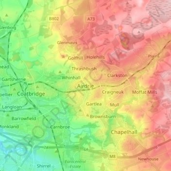
Nome: Mappa topografica Airdrie, altitudine, rilievo.
Luogo: Airdrie, North Lanarkshire, Scotland, ML6 6EQ, United Kingdom (55.82612 -4.02048 55.90612 -3.94048)
Altitudine media: 135 m
Altitudine minima: 47 m
Altitudine massima: 228 m
Fai una donazione
Equipaggiati per la tua prossima avventura:
In qualità di Affiliato Amazon, questo sito riceve una commissione sugli acquisti idonei, senza costi aggiuntivi per l’utente.
Altre mappe topografiche
Clicca su una mappa per visualizzarne la topografia, l'altitudine e il rilievo.
Forrestburn Reservoir
United Kingdom > Scotland > North Lanarkshire > Bentfoot
Altitudine media: 231 m
Cumbernauld
United Kingdom > Scotland > North Lanarkshire
Cumbernauld's name probably comes from the Gaelic comar nan allt, meaning "meeting of the burns or streams". There are differing views as to the etymology of this. One theory is that from its high point in the Central Belt, its streams flow both west to the River Clyde and east to the Firth of Forth so…
Altitudine media: 113 m
Fai una donazione
Equipaggiati per la tua prossima avventura:
In qualità di Affiliato Amazon, questo sito riceve una commissione sugli acquisti idonei, senza costi aggiuntivi per l’utente.
Cumbernauld
United Kingdom > Scotland > North Lanarkshire
Cumbernauld's name probably comes from the Gaelic comar nan allt, meaning "meeting of the burns or streams". There are differing views as to the etymology of this. One theory is that from its high point in the Central Belt, its streams flow both west to the River Clyde and east to the Firth of Forth so…
Altitudine media: 113 m