
Fai una donazione
Equipaggiati per la tua prossima avventura:
In qualità di Affiliato Amazon, questo sito riceve una commissione sugli acquisti idonei, senza costi aggiuntivi per l’utente.
Mappa topografica Papeete
Clicca sulla mappa per visualizzare l'altitudine.
Fai una donazione
Equipaggiati per la tua prossima avventura:
In qualità di Affiliato Amazon, questo sito riceve una commissione sugli acquisti idonei, senza costi aggiuntivi per l’utente.
Papeete
Previously, during the construction of the Faʻaiere water tower with a capacity of 150,000 litres for the drinking water supply of the city of Papeʻetē, a difference in altitude of 37 metres (121 ft) was overcome with a light railway laid on a 220 metres (720 ft) long inclined plane. A winch driven by a 12-horsepower Fowler or Decauville locomobile carried three narrow gauge railway trucks at a time, consuming up to 200 kilograms (440 lb) of coal per day for about sixty journeys. Paul Decauville mentioned in a letter to Governor Theodore Lacascade, dated 18 June 1891, an order for "15 kilometres (9.3 mi) of 600 mm (1 ft 11+5⁄8 in) portable rail tracks and about 12,000 francs of rolling stock, payable in three years," presumably for a tramway from Papeʻetē to Punaʻauia operated by hand or animals.
Fai una donazione
Equipaggiati per la tua prossima avventura:
In qualità di Affiliato Amazon, questo sito riceve una commissione sugli acquisti idonei, senza costi aggiuntivi per l’utente.
A proposito di questa mappa
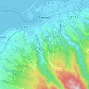
Nome: Mappa topografica Papeete, altitudine, rilievo.
Altitudine media: 224 m
Altitudine minima: -2 m
Altitudine massima: 1’133 m
Fai una donazione
Equipaggiati per la tua prossima avventura:
In qualità di Affiliato Amazon, questo sito riceve una commissione sugli acquisti idonei, senza costi aggiuntivi per l’utente.
Altre mappe topografiche
Clicca su una mappa per visualizzarne la topografia, l'altitudine e il rilievo.
Mont Orohena
France > French Polynesia > Windward Islands > Māhina
Mont Orohena is a mountain located in the South Pacific, on the island of Tahiti. With an elevation of 2,241 metres (7,352 ft) above sea level, it is the highest point of French Polynesia. Mont Orohena is an extinct volcano and ranks 7th in the world for topographic isolation.
Altitudine media: 1’282 m