
Fai una donazione
Equipaggiati per la tua prossima avventura:
In qualità di Affiliato Amazon, questo sito riceve una commissione sugli acquisti idonei, senza costi aggiuntivi per l’utente.
Mappa topografica Tallahassee
Clicca sulla mappa per visualizzare l'altitudine.
Fai una donazione
Equipaggiati per la tua prossima avventura:
In qualità di Affiliato Amazon, questo sito riceve una commissione sugli acquisti idonei, senza costi aggiuntivi per l’utente.
Tallahassee
Tallahassee's terrain is hilly by Florida standards, being at the southern end of the Red Hills Region, just above the Cody Scarp. The elevation varies from near sea level to just over 200 feet (61 m), with the state capitol on one of the highest hills in the city. The city includes two large lake basins, Lake Jackson and Lake Lafayette, and borders the northern end of the Apalachicola National Forest.
Fai una donazione
Equipaggiati per la tua prossima avventura:
In qualità di Affiliato Amazon, questo sito riceve una commissione sugli acquisti idonei, senza costi aggiuntivi per l’utente.
A proposito di questa mappa
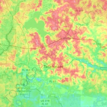
Nome: Mappa topografica Tallahassee, altitudine, rilievo.
Luogo: Tallahassee, Leon County, Florida, United States (30.34670 -84.37804 30.58724 -84.12995)
Altitudine media: 36 m
Altitudine minima: 2 m
Altitudine massima: 81 m
Fai una donazione
Equipaggiati per la tua prossima avventura:
In qualità di Affiliato Amazon, questo sito riceve una commissione sugli acquisti idonei, senza costi aggiuntivi per l’utente.
Altre mappe topografiche
Clicca su una mappa per visualizzarne la topografia, l'altitudine e il rilievo.
Miccosukee
United States > Florida > Leon County
By 1858, perhaps 200 ancestors of the modern Miccosukee and Seminole Tribes remained in Florida. They survived by moving into central and southern Florida to take advantage of the topography of Big Cypress and the Everglades, which was largely unknown to the remainder of the U.S. The American Civil War during…
Altitudine media: 59 m
Lake Ella
United States > Florida > Leon County > Tallahassee
In 1986, Lake Ella underwent extensive rehabilitation including sediment removal, reshaping of the shoreline, reducing the number of stormwater inflow pipes, and installation of an automatic alum treatment system. Lake Ella receives stormwater runoff from an urban watershed that is approximately 157 acres…
Altitudine media: 56 m
Fai una donazione
Equipaggiati per la tua prossima avventura:
In qualità di Affiliato Amazon, questo sito riceve una commissione sugli acquisti idonei, senza costi aggiuntivi per l’utente.
Lake Jackson
United States > Florida > Leon County
The lake is located in the Red Hills Region, and has fluctuated from periods of being dry to a maximum elevation of 96 feet (29 m) above sea level. The lake is approximately 7.5 miles (12 km) long and its area is 6.2 square miles (16 km2). There is no outflow from streams or runoff.
Altitudine media: 45 m
Fred O. Drake Park at Lake Ella
United States > Florida > Leon County > Tallahassee
Altitudine media: 56 m
Fai una donazione
Equipaggiati per la tua prossima avventura:
In qualità di Affiliato Amazon, questo sito riceve una commissione sugli acquisti idonei, senza costi aggiuntivi per l’utente.
Fai una donazione
Equipaggiati per la tua prossima avventura:
In qualità di Affiliato Amazon, questo sito riceve una commissione sugli acquisti idonei, senza costi aggiuntivi per l’utente.