
Fai una donazione
Equipaggiati per la tua prossima avventura:
In qualità di Affiliato Amazon, questo sito riceve una commissione sugli acquisti idonei, senza costi aggiuntivi per l’utente.
Mappa topografica Cedar Run
Clicca sulla mappa per visualizzare l'altitudine.
Fai una donazione
Equipaggiati per la tua prossima avventura:
In qualità di Affiliato Amazon, questo sito riceve una commissione sugli acquisti idonei, senza costi aggiuntivi per l’utente.
A proposito di questa mappa
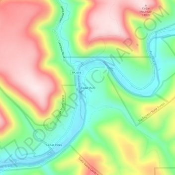
Nome: Mappa topografica Cedar Run, altitudine, rilievo.
Altitudine media: 405 m
Altitudine minima: 227 m
Altitudine massima: 623 m
Fai una donazione
Equipaggiati per la tua prossima avventura:
In qualità di Affiliato Amazon, questo sito riceve una commissione sugli acquisti idonei, senza costi aggiuntivi per l’utente.
Altre mappe topografiche
Clicca su una mappa per visualizzarne la topografia, l'altitudine e il rilievo.
Cascade Township
United States > Pennsylvania > Lycoming County
According to the United States Census Bureau, the township has a total area of 39.5 square miles (102.4 km2), of which 39.2 square miles (101.5 km2) are land and 0.3 square miles (0.8 km2), or 0.81%, are water. The northern part of the township drains to Pleasant Stream, which flows west to join Lycoming Creek…
Altitudine media: 459 m
Fai una donazione
Equipaggiati per la tua prossima avventura:
In qualità di Affiliato Amazon, questo sito riceve una commissione sugli acquisti idonei, senza costi aggiuntivi per l’utente.
Fai una donazione
Equipaggiati per la tua prossima avventura:
In qualità di Affiliato Amazon, questo sito riceve una commissione sugli acquisti idonei, senza costi aggiuntivi per l’utente.
McHenry Township
United States > Pennsylvania > Lycoming County
According to the United States Census Bureau, the township has a total area of 76.7 square miles (198.6 km2), of which 76.2 square miles (197.4 km2) are land and 0.46 square miles (1.2 km2), or 0.62%, are water. Pine Creek runs through the center of the township at the bottom of Pine Creek Gorge, with creek…
Altitudine media: 506 m
Fai una donazione
Equipaggiati per la tua prossima avventura:
In qualità di Affiliato Amazon, questo sito riceve una commissione sugli acquisti idonei, senza costi aggiuntivi per l’utente.
Cascade Township
United States > Pennsylvania > Lycoming County
According to the United States Census Bureau, the township has a total area of 39.5 square miles (102.4 km2), of which 39.2 square miles (101.5 km2) are land and 0.3 square miles (0.8 km2), or 0.81%, are water. The northern part of the township drains to Pleasant Stream, which flows west to join Lycoming Creek…
Altitudine media: 459 m
Fai una donazione
Equipaggiati per la tua prossima avventura:
In qualità di Affiliato Amazon, questo sito riceve una commissione sugli acquisti idonei, senza costi aggiuntivi per l’utente.
Fai una donazione
Equipaggiati per la tua prossima avventura:
In qualità di Affiliato Amazon, questo sito riceve una commissione sugli acquisti idonei, senza costi aggiuntivi per l’utente.