
Fai una donazione
Equipaggiati per la tua prossima avventura:
In qualità di Affiliato Amazon, questo sito riceve una commissione sugli acquisti idonei, senza costi aggiuntivi per l’utente.
Mappa topografica Rochester
Clicca sulla mappa per visualizzare l'altitudine.
Fai una donazione
Equipaggiati per la tua prossima avventura:
In qualità di Affiliato Amazon, questo sito riceve una commissione sugli acquisti idonei, senza costi aggiuntivi per l’utente.
Rochester
With a slightly higher altitude and without the same Urban heat island effect as the Twin Cities, the climate is warm-summer humid continental climate (Köppen: Dfb), which is cooler than the Twin Cities, despite being further south, with warm summers and cold winters. The city features four distinct seasons. Rochester sees on average 33.02 inches (839 mm) of rainfall and 51.9 inches (132 cm) of snowfall per year. Significant snow accumulation is common during the winter months. Spring and fall are transitional seasons, with a general warming trend during the spring and a general cooling trend during the fall. However, it is not uncommon to see some snowfall during the early month of spring and the later month of fall. Rochester is the second windiest city in the United States, with wind speeds averaging 12.6 mph (20.3 km/h). January to April are the windiest months on average, according to The Weather Channel. Rochester has been hit by two F4 tornadoes since 1950 (the first on May 10, 1953, and the other on September 16, 1962). The city has also been hit by two tornadoes in the past decade. On June 17, 2010, a tornado hit the city's northwest side, damaging or destroying several homes and businesses around the Lincolnshire neighborhood. Another tornado struck the city on June 4, 2019, causing damage to parts of Southwest Rochester.
Fai una donazione
Equipaggiati per la tua prossima avventura:
In qualità di Affiliato Amazon, questo sito riceve una commissione sugli acquisti idonei, senza costi aggiuntivi per l’utente.
A proposito di questa mappa
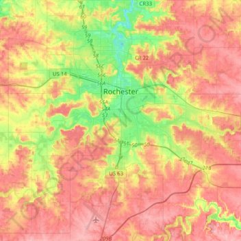
Nome: Mappa topografica Rochester, altitudine, rilievo.
Luogo: Rochester, Olmsted County, Minnesota, United States (43.88455 -92.57318 44.10825 -92.38900)
Altitudine media: 354 m
Altitudine minima: 286 m
Altitudine massima: 407 m
Fai una donazione
Equipaggiati per la tua prossima avventura:
In qualità di Affiliato Amazon, questo sito riceve una commissione sugli acquisti idonei, senza costi aggiuntivi per l’utente.
Altre mappe topografiche
Clicca su una mappa per visualizzarne la topografia, l'altitudine e il rilievo.