
Fai una donazione
Equipaggiati per la tua prossima avventura:
In qualità di Affiliato Amazon, questo sito riceve una commissione sugli acquisti idonei, senza costi aggiuntivi per l’utente.
Mappa topografica Red Mountain
Clicca sulla mappa per visualizzare l'altitudine.
Fai una donazione
Equipaggiati per la tua prossima avventura:
In qualità di Affiliato Amazon, questo sito riceve una commissione sugli acquisti idonei, senza costi aggiuntivi per l’utente.
A proposito di questa mappa
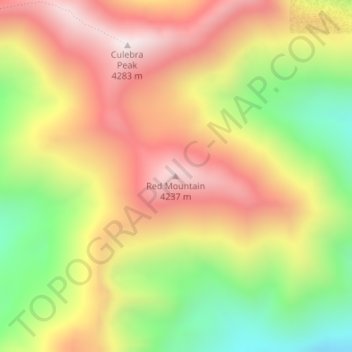
Nome: Mappa topografica Red Mountain, altitudine, rilievo.
Luogo: Red Mountain, Costilla County, Colorado, United States (37.11219 -105.18117 37.11229 -105.18107)
Altitudine media: 3’862 m
Altitudine minima: 3’397 m
Altitudine massima: 4’276 m
Fai una donazione
Equipaggiati per la tua prossima avventura:
In qualità di Affiliato Amazon, questo sito riceve una commissione sugli acquisti idonei, senza costi aggiuntivi per l’utente.
Altre mappe topografiche
Clicca su una mappa per visualizzarne la topografia, l'altitudine e il rilievo.
Fort Garland
United States > Colorado > Costilla County > Fort Garland
Fort Garland is located at an elevation of 7,936 ft (2,419 m) in northern Costilla County. Fort Garland is at the crossroads of U.S. Route 160 and Colorado State Highway 159, which leads south towards Taos and Santa Fe, New Mexico. The town of Blanca is 4 miles (6.4 km) west on U.S. Route 160. Walsenburg is 47…
Altitudine media: 2’427 m
Fai una donazione
Equipaggiati per la tua prossima avventura:
In qualità di Affiliato Amazon, questo sito riceve una commissione sugli acquisti idonei, senza costi aggiuntivi per l’utente.
Fort Garland
United States > Colorado > Costilla County > Fort Garland
Fort Garland is located at an elevation of 7,936 ft (2,419 m) in northern Costilla County. Fort Garland is at the crossroads of U.S. Route 160 and Colorado State Highway 159, which leads south towards Taos and Santa Fe, New Mexico. The town of Blanca is 4 miles (6.4 km) west on U.S. Route 160. Walsenburg is 47…
Altitudine media: 2’427 m
Fai una donazione
Equipaggiati per la tua prossima avventura:
In qualità di Affiliato Amazon, questo sito riceve una commissione sugli acquisti idonei, senza costi aggiuntivi per l’utente.