
Fai una donazione
Equipaggiati per la tua prossima avventura:
In qualità di Affiliato Amazon, questo sito riceve una commissione sugli acquisti idonei, senza costi aggiuntivi per l’utente.
Mappa topografica Ait Ahmed
Clicca sulla mappa per visualizzare l'altitudine.
Fai una donazione
Equipaggiati per la tua prossima avventura:
In qualità di Affiliato Amazon, questo sito riceve una commissione sugli acquisti idonei, senza costi aggiuntivi per l’utente.
A proposito di questa mappa
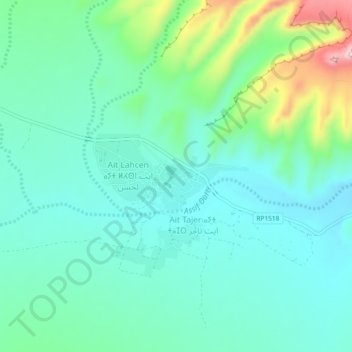
Nome: Mappa topografica Ait Ahmed, altitudine, rilievo.
Altitudine media: 1’078 m
Altitudine minima: 1’015 m
Altitudine massima: 1’280 m
Fai una donazione
Equipaggiati per la tua prossima avventura:
In qualità di Affiliato Amazon, questo sito riceve una commissione sugli acquisti idonei, senza costi aggiuntivi per l’utente.
Altre mappe topografiche
Clicca su una mappa per visualizzarne la topografia, l'altitudine e il rilievo.
M'Hamid El Ghizlane
Morocco > Drâa-Tafilalet > Cercle de Zagora دائرة زاكورة
M'Hamid lies at an altitude of about 500 metres (1,600 ft) above sea level and about 24 kilometres (15 mi) from the Algerian border at the edge of the Sahara. M'Hamid can be reached at the end of National Route 9 from Ouarzazate (260 km) via Zagora (approx. 97 kilometres (60 mi)). Mhamid lies on the Wadi Draa,…
Altitudine media: 642 m
Fai una donazione
Equipaggiati per la tua prossima avventura:
In qualità di Affiliato Amazon, questo sito riceve una commissione sugli acquisti idonei, senza costi aggiuntivi per l’utente.
Oued Naam وادي النعام
Morocco > Drâa-Tafilalet > Cercle d'Errachidia دائرة الرشيدية
Altitudine media: 1’077 m
M'Hamid El Ghizlane
Morocco > Drâa-Tafilalet > Cercle de Zagora دائرة زاكورة
M'Hamid lies at an altitude of about 500 metres (1,600 ft) above sea level and about 24 kilometres (15 mi) from the Algerian border at the edge of the Sahara. M'Hamid can be reached at the end of National Route 9 from Ouarzazate (260 km) via Zagora (approx. 97 kilometres (60 mi)). Mhamid lies on the Wadi Draa,…
Altitudine media: 642 m
Fai una donazione
Equipaggiati per la tua prossima avventura:
In qualità di Affiliato Amazon, questo sito riceve una commissione sugli acquisti idonei, senza costi aggiuntivi per l’utente.
Tinghir
Morocco > Drâa-Tafilalet > Pachalik de Tinghir باشوية تنغير
Tinghir is an oasis about 30 kilometres (19 mi) long and about 4 kilometres (2.5 mi) wide. The climate is arid subtropical: hot, dry winters about altitude (1,430 metres (4,690 ft)). There are a few rainy days per year, with the greatest precipitation in fall and winter.
Altitudine media: 1’352 m
Haut Atlas Oriental National Park
This site covers 55,252 ha of the High Atlas between Midelt and Er Rachidia. The base rock consists of limestone with some igneous intrusions. The site ranges in altitude from 1,645 m in the bed of the Oued Arheddou to 3,102 m at the summit of Jbel Tanrhourt. At its western end it includes the twin lakes of…
Altitudine media: 1’984 m
Fai una donazione
Equipaggiati per la tua prossima avventura:
In qualità di Affiliato Amazon, questo sito riceve una commissione sugli acquisti idonei, senza costi aggiuntivi per l’utente.
M'Hamid El Ghizlane
Morocco > Drâa-Tafilalet > Cercle de Zagora دائرة زاكورة
M'Hamid lies at an altitude of about 500 metres (1,600 ft) above sea level and about 24 kilometres (15 mi) from the Algerian border at the edge of the Sahara. M'Hamid can be reached at the end of National Route 9 from Ouarzazate (260 km) via Zagora (approx. 97 kilometres (60 mi)). Mhamid lies on the Wadi Draa,…
Altitudine media: 642 m
Errachidia
Morocco > Drâa-Tafilalet > Pachalik de Er Rachidia باشوية الرشيدية
Altitudine media: 1’036 m
Fai una donazione
Equipaggiati per la tua prossima avventura:
In qualità di Affiliato Amazon, questo sito riceve una commissione sugli acquisti idonei, senza costi aggiuntivi per l’utente.
Tinghir
Morocco > Drâa-Tafilalet > Pachalik de Tinghir باشوية تنغير
Tinghir is an oasis about 30 kilometres (19 mi) long and about 4 kilometres (2.5 mi) wide. The climate is arid subtropical: hot, dry winters about altitude (1,430 metres (4,690 ft)). There are a few rainy days per year, with the greatest precipitation in fall and winter.
Altitudine media: 1’352 m
Imilchil
Morocco > Drâa-Tafilalet > Cercle d'Imilchil
It is located at an elevation of 2119 m in the valley of Asif Mellulen ("white river"). The area of Imilchil is home to the Ayt Hdiddu tribe, belonging to the Ait Yafelman confederation, and the inhabitants speak Central Atlas Tamazight. Tourist attractions in the area include the caves of Axyam (Akhyam), the…
Altitudine media: 2’484 m
Fai una donazione
Equipaggiati per la tua prossima avventura:
In qualità di Affiliato Amazon, questo sito riceve una commissione sugli acquisti idonei, senza costi aggiuntivi per l’utente.
Ouarzazate
Morocco > Drâa-Tafilalet > Pachalik d'Ouarzazate
Ouarzazate is at an elevation of 1,151 metres (3,776 ft) in the middle of a bare plateau south of the High Atlas Mountains, with a desert to the city's south.
Altitudine media: 1’144 m