
Fai una donazione
Equipaggiati per la tua prossima avventura:
In qualità di Affiliato Amazon, questo sito riceve una commissione sugli acquisti idonei, senza costi aggiuntivi per l’utente.
Mappa topografica McAdoo
Clicca sulla mappa per visualizzare l'altitudine.
Fai una donazione
Equipaggiati per la tua prossima avventura:
In qualità di Affiliato Amazon, questo sito riceve una commissione sugli acquisti idonei, senza costi aggiuntivi per l’utente.
McAdoo
According to the United States Census Bureau, the borough has a total area of 0.3 square miles (0.78 km2), all land. McAdoo's elevation is 1700 feet above sea level. It is on the crest of Broad Mountain and straddles the divide between the Delaware and Susquehanna watersheds. Pennsylvania Route 309 (Kennedy Drive) is the main north-to-south thoroughfare. Interstate 81 runs a short distance west of town and parallel to PA 309. The two routes have an access highway connecting them just south of McAdoo at exit 138 of I-81. McAdoo has a warm-summer humid continental climate (Dfb) and the hardiness zone is 6a. Average monthly temperatures range from 23.5 °F in January to 70.1 °F in July.
Fai una donazione
Equipaggiati per la tua prossima avventura:
In qualità di Affiliato Amazon, questo sito riceve una commissione sugli acquisti idonei, senza costi aggiuntivi per l’utente.
A proposito di questa mappa
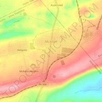
Nome: Mappa topografica McAdoo, altitudine, rilievo.
Altitudine media: 528 m
Altitudine minima: 445 m
Altitudine massima: 580 m
Fai una donazione
Equipaggiati per la tua prossima avventura:
In qualità di Affiliato Amazon, questo sito riceve una commissione sugli acquisti idonei, senza costi aggiuntivi per l’utente.
Altre mappe topografiche
Clicca su una mappa per visualizzarne la topografia, l'altitudine e il rilievo.
Park Place
United States > Pennsylvania > Schuylkill County > Mahanoy Township
Altitudine media: 515 m
Fai una donazione
Equipaggiati per la tua prossima avventura:
In qualità di Affiliato Amazon, questo sito riceve una commissione sugli acquisti idonei, senza costi aggiuntivi per l’utente.
Blue Mountain
United States > Pennsylvania > Schuylkill County > Washington Township
The ridge of Blue Mountain runs for 150 miles (240 km) through Pennsylvania, reaching an elevation of 2,270 feet (690 m) above sea level just north of the Pennsylvania Turnpike, near the borough of Newburg. Most of the ridgecrest, however, only reaches between 1,400 and 1,700 feet (430 and 520 m) in elevation.…
Altitudine media: 226 m
Nuremberg
United States > Pennsylvania > Schuylkill County > North Union Township
Altitudine media: 377 m