
Mappa topografica Sleaford
Clicca sulla mappa per visualizzare l'altitudine.
Sleaford
Although hardly damaged in the First and Second World Wars, Sleaford has close links with the Royal Air Force due to proximity to several RAF bases, including RAF Cranwell and RAF Waddington. Lincolnshire's topography – flat and open countryside – and its location in the east of the country made it ideal for the airfields being constructed in the First World War. Work began on Cranwell in late 1915; it was designated an RAF base in 1918 and the RAF College opened in 1920 as the world's first air academy. A Cranwell branch railway linking Sleaford station with the RAF base opened in 1917 and closed in 1956. During the Second World War, Lincolnshire was "the most significant location for bomber command" and Rauceby Hospital, south-west of Sleaford, was requisitioned by the RAF as a specialist burns unit which the plastic surgeon Archibald McIndoe regularly visited.
A proposito di questa mappa
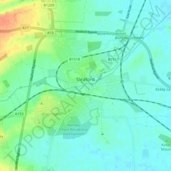
Nome: Mappa topografica Sleaford, altitudine, rilievo.
Altitudine media: 18 m
Altitudine minima: 7 m
Altitudine massima: 48 m
Altre mappe topografiche
Clicca su una mappa per visualizzarne la topografia, l'altitudine e il rilievo.
Threekingham
United Kingdom > England > Lincolnshire > North Kesteven > Threekingham
Altitudine media: 30 m
Helpringham
United Kingdom > England > Lincolnshire > North Kesteven > Helpringham
Altitudine media: 8 m
Doddington
United Kingdom > England > Lincolnshire > North Kesteven > Doddington
Altitudine media: 19 m
Quarrington
United Kingdom > England > Lincolnshire > North Kesteven
According to the Köppen classification, the British Isles experience a maritime climate characterised by relatively cool summers and mild winters. Lincolnshire's position on the east of the Isles allows for a sunnier and warmer climate relative to the national average, and it is one of the driest counties in…
Altitudine media: 21 m
Long Holt Wood
United Kingdom > England > Lincolnshire > North Kesteven > Nocton
Altitudine media: 20 m
Three Kings Deer
United Kingdom > England > Lincolnshire > North Kesteven > Threekingham
Altitudine media: 24 m