
Fai una donazione
Equipaggiati per la tua prossima avventura:
In qualità di Affiliato Amazon, questo sito riceve una commissione sugli acquisti idonei, senza costi aggiuntivi per l’utente.
Mappa topografica Taylor Peak
Clicca sulla mappa per visualizzare l'altitudine.
Fai una donazione
Equipaggiati per la tua prossima avventura:
In qualità di Affiliato Amazon, questo sito riceve una commissione sugli acquisti idonei, senza costi aggiuntivi per l’utente.
A proposito di questa mappa
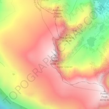
Nome: Mappa topografica Taylor Peak, altitudine, rilievo.
Luogo: Taylor Peak, Grand County, Colorado, United States (40.27473 -105.68090 40.27483 -105.68080)
Altitudine media: 3’646 m
Altitudine minima: 3’072 m
Altitudine massima: 4’015 m
Fai una donazione
Equipaggiati per la tua prossima avventura:
In qualità di Affiliato Amazon, questo sito riceve una commissione sugli acquisti idonei, senza costi aggiuntivi per l’utente.
Altre mappe topografiche
Clicca su una mappa per visualizzarne la topografia, l'altitudine e il rilievo.
Grand Lake
United States > Colorado > Grand County
Established in 1881, Grand Lake sits at an elevation of 8,369 feet (2,551 m) and derives its name from the lake on whose shores it is situated: Grand Lake, the largest natural body of water in Colorado. The town of Grand Lake was originally an outfitting and supply point for the mining settlements of Lulu…
Altitudine media: 2’630 m
Winter Park
United States > Colorado > Grand County
Its elevation ranges from approximately 8,700 to 12,060 feet (2,650 to 3,680 m) above sea level, and is considered sub-alpine country. It is snow-covered for about six months a year. Although the town center is at about 9,000 feet (2,700 m) above sea level, Winter Park, using administrative boundaries as a…
Altitudine media: 3’061 m
Tabernash
United States > Colorado > Grand County > Tabernash
On August 10, 1984, a Cessna L-19 Bird Dog (registration N4584A), piloted by James Jeb Caddell, 36, crashed in a forest near Tabernash. The aircraft was en route from Granby to Jeffco Airport, Colorado. Despite the efforts of a search party, the two men could not be located, as the plane had flipped over and…
Altitudine media: 2’593 m
Fai una donazione
Equipaggiati per la tua prossima avventura:
In qualità di Affiliato Amazon, questo sito riceve una commissione sugli acquisti idonei, senza costi aggiuntivi per l’utente.
Winter Park
United States > Colorado > Grand County
Its elevation ranges from approximately 8,700 to 12,060 feet (2,650 to 3,680 m) above sea level, and is considered sub-alpine country. It is snow-covered for about six months a year. Although the town center is at about 9,000 feet (2,700 m) above sea level, Winter Park, using administrative boundaries as a…
Altitudine media: 3’061 m
Fai una donazione
Equipaggiati per la tua prossima avventura:
In qualità di Affiliato Amazon, questo sito riceve una commissione sugli acquisti idonei, senza costi aggiuntivi per l’utente.
Fraser
United States > Colorado > Grand County
Fraser is located in southeastern Grand County at 39°56′39″N 105°48′48″W / 39.94417°N 105.81333°W / 39.94417; -105.81333 (39.944158, -105.813355), at an elevation of 8,574 feet (2,613 m) above sea level. It is bordered to the south by the town of Winter Park and to the north by…
Altitudine media: 2’696 m
Fai una donazione
Equipaggiati per la tua prossima avventura:
In qualità di Affiliato Amazon, questo sito riceve una commissione sugli acquisti idonei, senza costi aggiuntivi per l’utente.
Grand Lake
United States > Colorado > Grand County
Established in 1881, Grand Lake sits at an elevation of 8,369 feet (2,551 m) and derives its name from the lake on whose shores it is situated: Grand Lake, the largest natural body of water in Colorado. The town of Grand Lake was originally an outfitting and supply point for the mining settlements of Lulu…
Altitudine media: 2’630 m
Tabernash
United States > Colorado > Grand County > Tabernash
On August 10, 1984, a Cessna L-19 Bird Dog (registration N4584A), piloted by James Jeb Caddell, 36, crashed in a forest near Tabernash. The aircraft was en route from Granby to Jeffco Airport, Colorado. The wreckage was found by backpackers three years later on August 23, 1987. A 6½ minute video shot from a…
Altitudine media: 2’593 m
Fai una donazione
Equipaggiati per la tua prossima avventura:
In qualità di Affiliato Amazon, questo sito riceve una commissione sugli acquisti idonei, senza costi aggiuntivi per l’utente.